- On July 2, Mumbai witnessed the second heaviest rainfall in a day, in the last 45 years.
- An outdated and choked stormwater drainage system does not have the capacity to deal with intense rains.
- Razing of mangroves and tree cover for development, pollution and interference with rivers and unsustainable construction have reduced the city’s natural defences against floods.
When the rain poured down on Mumbai last week, drowning the city in what now seems like an annual affair, it once again brought up the question – why is Mumbai never prepared for a deluge? The answers, unfortunately, remain the same – an outdated drainage system, destruction of the natural barriers against climate change and unsustainable urbanisation are weighing heavy on the city’s capacity to deal with heavy monsoons and climate change.
India’s commercial capital in the western state of Maharashtra, the metropolis of some 22 million, is inundated at least one day every year with heavy rains. Suburban railways, road transport, air traffic and normal public life is disrupted for a few days each time. This time, starting on July 1, which was the sixth day of the monsoons, incessant rains for 48 hours coupled with a stressed drainage system created havoc, resulting in the death of over 30 people due to wall collapse and other rain-related incidents. Thousands of commuters were stuck in local trains till late at night. A commercial aircraft skidded off the primary runway and disrupted over 200 flights for the entire week.
On July 2, Mumbai witnessed the second heaviest rainfall in a day, in the last 45 years and the highest in a decade. The highest rainfall recorded in a single day remains July 26, 2005.
Ironically, barely a week before Mumbai was flooded with rains, Maharashtra struggled with drought on 50 percent of its geographical area affecting life and livelihood of millions. Hardships went up as the monsoon skipped its official arrival date of June 10, by a fortnight. Mumbai too was facing a 10 percent water cut since November 2018. The water stock in seven lakes supplying water to Mumbai dipped to six percent in June this year.
This stark contrast, between extremes, flood and water scarcity in the same state and parts of the same city, continues to expose the poor management of water resources.
“The city’s inability to bear heavy downpours exposes the failure of the civic body to improve its drainage system and political system that has allowed unbridled development which affected the region’s natural capacity to absorb heavy rainfall,” Debi Goenka, an environment activist, told Mongabay-India.
The administrators meanwhile pointed to the changing climate and its impact on the monsoon. Chief minister Devendra Fadnavis told the Legislative Assembly that Mumbai suburbs witnessed extremely heavy rains up to 375-400 mm in three-four hours which was unprecedented. The Municipal Commissioner of Mumbai Pravin Pardeshi, while speaking to the media, attributed climate change for the floods saying that Mumbai received rainfall equal to a month’s in just two days. He said that Mumbai has been pumping out a massive amount of rainwater something no other city in the world can match.

An outdated drainage system
Mumbai’s inability to drain out rainwater effectively is in part due to its old drainage system that cannot cope with the capacity of rainfall that the city witnesses on days like these. The city’s stormwater drainage system, almost a century old, is a network of surface drains across 2000 km and underground drains of about 400 km. “But they (drains) are heavily silted and punctured at many places. Their outfall to the sea is affected by high tides as 42 of 45 outfall lack flood gates,” points out the Comptroller and Auditor General of India (CAG), in its report tabled in the state Assembly on July 2.
The report also states that the city’s drains have the capacity for 25 mm per hour rainfall in low tide while rainfall on a few days of the monsoon crosses over 50 mm an hour.
The Mumbai floods of 2005, where more than 1,095 lives were lost amid 945 mm rainfall and high tides gave the city the wake up call it needed to upgrade its drainage system.
The Brihanmumbai Storm Water Disposal System (BRIMSTOWAD) project to overhaul Mumbai’s drainage system was proposed in 1993 after the 1985 floods and was intended to be a longterm road map for the city’s vulnerability to flooding. However, no action was taken due to the financial cost of the project until the 2005 floods when the Chitale committee formed to analyse the deluge also recommended to upgrade Mumbai’s old stormwater drainage system.
As of 2019, work is reportedly in progress to increase the capacity of the stormwater drains to handle rainfall intensity of 50 mm/hour. But varied complications, outdated methodologies, rampant encroachments and associated rising costs prove to be regular barriers to the progress of this project.
“Lack of political will, poor governance and unplanned development at the cost of Mumbai’s natural flood cover are responsible for this. The Shivsena-Bhartiya Janta Party ruled civic body has miserably failed to upgrade and clean the stormwater drainage system,” Milind Deora, the opposition leader and the former chief of Mumbai’s Indian National Congress party told Mongabay-India.
On July 1 itself, the Municipal Corporation of Greater Mumbai (MCGM) had registered a criminal case against a private firm for dumping debris near a drain thus blocking the passage of rainwater. The same day Bombay High Court reserved its judgement on a petition against the construction of a Coastal Road alongside the Arabian Sea to link the two ends of Mumbai allegedly without environment clearance and chief minister Devendra Fadnavis was accused of giving clearance to a hotel project in no-development zone.
How Mumbai’s landscape changed over the century
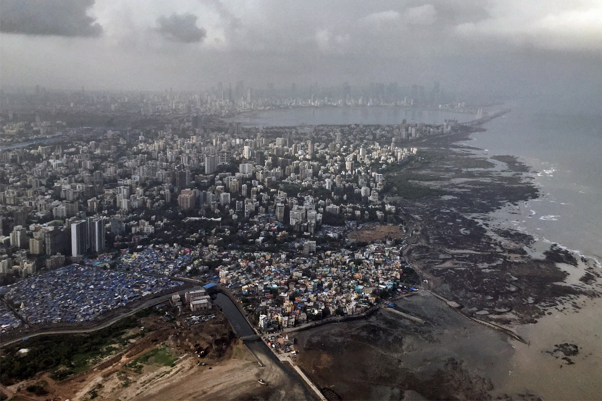
A journey across Mumbai today is a series of works in progress. Some necessary, some debatable, but all pretty much focused on the needs of the city’s over 22 million human residents. Excavators and cranes loom over the city roads, drillings sounds mix with the honking of cars and patches of natural green are replaced with built-up spaces to meet the city’s vast and varied housing requirements.
The Mumbai metro, the coastal road, a new airport, the Mumbai-Ahmedabad bullet train project and a series of other road links are being developed to ensure that the city keeps moving. But as Mumbai rushes to keep up with its reputation of a city that never stops, these markers of urban growth are swallowing up the forests, coastline and ecology as they spread through the metropolis.
The peninsular city bursting with concrete structures was once a mixed wetland ecosystem of mangrove forests and over the past century, mangroves have been levelled and waterways filled with construction debris, leaving the city vulnerable to flooding without its natural protectors.
Read more: Infrastructure and environment battle it out in the maximum city.
The Flood Preparedness Guidelines 2019 report by the Municipal Corporation of Greater Mumbai notes that the process of urbanisation has played a major role aggravating the problem as it has caused significant alterations to hydrology, morphology, habitat and ecology of the city. Inadequate drainage, overflow of the Mithi river and a combination of high tides and high river flow all contribute to the regular floods in Mumbai, it states.
Reclamation has been increasingly seen as a solution to limited land in Mumbai. The city’s area has increased from 437 sq km in 1991 to 482 sq km now due to reclamations and years of silting by the sea. The coastal tract of Mumbai is hence low lying, with the average height at some points just a metre about mean sea level. The major projects developed on reclaimed land includes Bandra Worli Sea Link, the Bandra Kurla Complex and Lokhandwala complex.
Environmentalist Stalin D. of Vanashakti says, “Any kind of reclamation is bound to alter the tidal pattern and intensity.”
Mumbai used to be two groups of islands, with the southern island city said to have consisted of seven smaller islands that have were developed into one unit through reclamation projects. The first land reclamation in Mumbai was undertaken in the first decade of the 18th century and more continued thereafter. While the success of reclamation is debatable and alternative experiences of the project lesser documented, the overarching idea of land reclamation is propagated to be a symbol of “urban growth” that has continued well into modern times.

Mangroves, the guardians of the coast
Mangrove forests, found at the intersection of land and sea, are natural defenders against the impacts of climate change. As storms become more erratic and severe due to climate change, the importance of mangroves with their complex root system holding on to the land becomes pronounced.
As per an estimate by Vanashakti, the metro city has lost 40 percent of its mangrove forest cover between the early 1990s and 2005 putting communities at risk. Using satellite images, the NGO has estimated that Mumbai’s mangrove cover is shrunk by 15-20 percent in the last five years due to the dumping of debris and encroachment. Meanwhile, the State of Forest report 2017 by Forest Survey of India notes that Mumbai (city and suburban) has 66 square km of mangroves and Thane has 90 sq km, noting an increase from the 2015 assessment.
The available data of the city’s mangrove cover, while conflicting in parts, does not rule out the role of mangroves in protecting the city against storm surges and coastal erosion as well as the threats these ecosystems face from changing land use patterns and human activity.
Debi Goenka warns, “We should brace up for more challenging times ahead as additional 355 hectares of mangroves are being wiped out for diversion for Navi Mumbai airport, bullet train project, Mumbai Trans Harbour Link and Malad Sewage Treatment Plant.”
“Since Forest Survey of India’s assessment has revealed that Mumbai’s mangrove cover has increased, the politicians are out to exploit it further,” said Stalin.
While the loss of big parcels of mangrove cover gets media attention, the small-time encroachments such as dumping of debris and encroachments on land which eventually is overtaken by real estate developers remain under wraps, which is a cause of concern, say activists.
Dharmesh Barai, environment activist, says, “The administration and local politicians ignore our repeated alerts about encroachments in new areas.”
When nature’s systems fail with human intervention
In addition to drainage upgrades and other infrastructural interventions to keep Mumbai from flooding, experts have time and again emphasised the importance of maintaining natural systems that keep floodwater in check. Mumbai is lucky to have an ecological landscape that can naturally protect the city, provided it is maintained.
The rivers in Mumbai, which are natural stormwater drainage systems, are in a poor state where they can no longer serve that function. One of the major rivers, Mithi, has become a veritable sewer, choked with domestic and industrial waste and overflows every monsoon.
The other major rivers — Dahisar, Poisar and Oshiwara rivers — are also prone to overflowing because of similar reasons. The wetlands along the river, too, have disappeared, say activists.
Additionally, Mumbai is blessed with 2,100 hectares of salt pans which act as buffers for tide and heavy rainfall but were deemed not to be wetlands following a revision of the Wetlands (Conservation and Management) Rules in 2017. Over 15 percent of the salt pan cover has been opened up for construction of affordable housing.
Environmentalist Stalin D. of NGO Vanashakti says, “Saltpans are the lowest lying areas of the city. If you start converting them into concrete, first the chances of floods will go up and then entire saltpan will be grabbed by land sharks who get the rules bent in their favour.”
Tree covers are also ecological pathways to reduce the impact of flooding as roots create channels in the soil for the water to seep through. Mumbai’s Sanjay Gandhi National Park, an 82 sq km area, is a massive green cover and functioning lungs of the city, which is being suffocated due to encroachment and other construction activities. The adjoining Aarey Milk Colony and part of its tree cover is also under threat from a proposed metro line car shed.
As the natural protectors against climate change are razed down to make way for a growing population’s habitat, it’s the people themselves that will be exposed directly to the risk of flooding.
The situation of Mumbai is aptly summed up in by Amitav Ghosh in his book The Great Derangement: “Mumbai is a finger sticking out into the open sea. If a super storm were to hit Mumbai, Mumbai would have no defences. The storm surge would go straight into the city. You’re literally thinking of a 30 – 40 foot wave just going into the city…”

Climate change and communities at risk
A ranking of world cities most exposed to coastal floods listed Mumbai at the very top, in terms of the population exposed to coastal floods. The study estimated that by 2070, Mumbai will move to second place, overtaken by Kolkata, but with about five times more people exposed to coastal floods as compared to 2005. “Most of them would be from tribal, fishing and marginalised communities,” says Barai.
Coastal cities around the world are prone to extreme weather events. Over 21 of the world’s 31 megacities lie along a coastline and many share the threat of severe storms, heavier rainfalls and rise in sea levels. By reducing emissions in line with the Paris climate agreement, coastal cities will certainly be saved from the worst, but even small amounts of global warming and sea level rise will directly influence them.
Cities are already on the pathway to adapt to the changing climate. New York city protects its shoreline by codes that provide updated flood risks. In Jakarta, seawalls are a short term measure while a longer-term plan to relocate people in calamity is in pipeline, according to a report.
Banner image: As Mumbai’s natural defenders against floods are razed down to make way for housing, the residents are the ones exposed to the risk of floods. Photo by Kartik Chandramouli/Mongabay.