
- Pichavaram mangroves in the shrinking Cauvery delta in Tamil Nadu act as a modest carbon sink in the winter season and as a source in the summer, finds a recent study.
- Changes in temperature, rainfall, salinity, and freshwater flow shape the carbon-storing potential of the mangroves.
- Climate change-induced changes in rainfall patterns, temperature, and salinity are likely to reduce the mangroves’ carbon-storing capacity.
The Pichavaram mangroves in the southern Indian state of Tamil Nadu, that had helped lessen the devastating impacts of the 2004 Asian tsunami in the region, capture and hold a “modest” amount of carbon dioxide, a study has said.
According to the study carried out by the Chennai-based M. S. Swaminathan Research Foundation (MSSRF) and Indian Institute of Tropical Meteorology (IITM), Pune, the mangroves squirrel away 1.83 metric tonne carbon (tC) per hectare per year — which is equivalent to emissions from the use of 818 liters (180 gallons) of diesel.
But scientists said changes in rainfall, salinity, and temperature with climate change will likely impact the carbon exchange of the mangrove expanse at Pichavaram, fed by the heavily dammed and shrinking Cauvery delta. Pichavaram, in flood and cyclone-prone Cuddalore district, is about 220 km from Tamil Nadu’s state capital Chennai and is a popular tourist destination.
“Mangrove wetlands are known to be sinks/sources for greenhouse gases such as carbon dioxide, methane, nitrous oxide. Our study shows that Pichavaram mangroves act as a modest carbon sink in the winter season and as a carbon source in the summer,” said R. Ramasubramanian, of Coastal Systems Research, at MSSRF.
But the authors caution that the carbon sink capability may decline in the future due to rising temperatures, decreasing rainfall patterns, variation in salinity, and changes in tidal inundation patterns. “The protection and management of these forests can be leveraged as a strategy to reduce carbon dioxide emissions,” said Ramasubramanian.
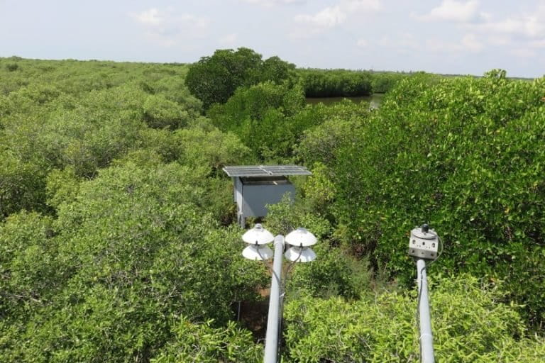
The study was conducted under the MetFlux India project under the Ministry of Earth Sciences, which seeks to understand the source or sink nature of Indian forest ecosystems through installations of flux towers that measure the amount of gas – such as carbon dioxide – and energy flux exchanged between the atmosphere and terrestrial ecosystems.
The Pichavaram mangrove study documents carbon dioxide flux measurement for a period of one year (October 2017–September 2018) from a flux tower installed in the mangroves as part of the project.

Unlike other tropical forests, for which the bulk of carbon storage is in the biomass, mangrove carbon is primarily stored in the soil. The carbon stored in coastal and marine ecosystems is called blue carbon.
Coastal ecosystems such as mangroves, tidal marshes, and seagrass meadows sequester and store more carbon per unit area than terrestrial forests and are now being recognised for their role in mitigating climate change.
“The mangroves should be conserved to preserve the below-ground carbon stored. If they are degraded, the stored carbon will be lost. The wetland will become the source of carbon dioxide. Now, blue carbon from the mangroves is being marketed,” said Ramasubramanian.
Mangrove scientist P. Ragavan, who was not associated with the study, adds that the research on Pichavaram addresses the research/data gap in blue carbon inventories of Indian mangroves.
“Blue carbon must be leveraged to finance coastal resilience, but it requires standard frameworks. In India blue carbon inventory is still in the infant stage, so still, long way to go,” Ragavan of Physical Research Laboratory, Ahmedabad, told Mongabay-India.
A 2018 study on the environmental value of mangroves found that blue carbon has been underestimated by up to 50 percent in coasts with limestone rock, such as those found on the southern tip of Florida in the United States and in the Caribbean. They also found that blue carbon has been overestimated by up to 86 percent in coastal deltas in previous studies.
The India State of Forest Report 2019 documented an increase in mangrove cover in the country by 54 sq. km. as compared to the previous assessment, but marked a decrease of mangrove cover in Tamil Nadu (by four sq. km.), West Bengal (by two sq. km.) and Andaman and Nicobar Islands (by one sq. km.).
Multiple factors shape mangrove blue carbon
The Pichavaram mangrove expanse extends across 1100 hectares (11 square km) of reserved forest area featuring a mosaic of mangrove species, marshes, and mudflats flanked by Vellar and Coleroon estuaries of the Cauvery delta. While the Bay of Bengal is the source of seawater for the mangroves, the estuarine complex supplies freshwater.
The mangroves span 51 islets separated by a web of waterways connecting the Vellar and Coleroon estuaries. Communities of five revenue villages depend on the fishery and forestry resources of the Pichavaram mangrove wetlands.
Several factors such as rainfall, salinity, temperature, and availability of freshwater shape the net change in carbon storage in the ecosystem (net ecosystem productivity or NEP) in several ways, said Ramasubramanian.
“Higher rainfall reduces salinity and temperature and increases productivity. Freshwater is good for mangroves because with higher salinity the plants will be stunted and productivity will reduce. With an increase in temperature, productivity goes down.”
Sea level rise (SLR) is a major potential climate change threat to mangroves as they are sensitive to changes in inundation duration and frequency as well as salinity levels. Additionally, large parts of the coastal zone in Cuddalore are low-lying with gentle slope, resulting in major inundation with seawater.
“An increase in the duration of inundation can lead to mortality and changes in the species composition leading to a reduction in productivity,” explained Ramasubramanian, adding sea-level rise will increase the inundation of mangroves which may lead to an increase in methane production which is more harmful than carbon dioxide.” Methane is also a greenhouse gas, which has a higher warming effect than carbon dioxide.
According to a 2018 study on the predicted impacts of sea-level rise at Vellar–Coleroon estuarine region in projected sea level rise scenario of 0.5 m and 1 m, of the total dense mangrove area of 813 hectares, as much as 265 hectare (32 percent) will be inundated to 0.5 metre SLR. As much as 46 percent (373 hectare) of dense mangroves will be submerged in a one metre SLR.
While mangroves are considered as a bioshield against cyclones, cyclonic disturbances may hamper the mangroves’ ability to store carbon by uprooting them, leading to a loss of canopy, loss in photosynthesis, and lowering productivity. In degraded mangroves, the buried carbon will be released due to microbial action. The intact mangrove will not release carbon dioxide, said Ramasubramanian.
Unlike other parts of the country that recharge principally during the summer monsoon, Pichavaram mangroves are watered during the northeast monsoon season from October to December. This means winter or post-monsoon season for Pichavaram is from January–March, summer from April–June, and pre-monsoon stretches from July–September.

Subramanian said 95 percent of the carbon in Pichavaram was sequestered in the winter season (post-monsoon and pre-monsoon seasons) while the mangroves were nearly carbon-neutral during the northeast monsoon season and acted as a net source during the summer months.
So, moderate temperature and moderate saline water appear to favour the mangroves’ ability to store maximum carbon in the winter season, said Ramasubramanian.
Less rainfall, freshwater flow reduce Pichavaram productivity
The Pichavaram mangrove flora is split into two zones: Rhizophora in the fringes and Avicennia in the interior are conspicuous. The Avicennia zone comprises nearly 75 percent of the total area under mangroves. However, these mangroves are shorter since the wetland receives less rainfall and freshwater flow, impacting their productivity.
“At Pichavaram, the mangroves are shorter since the wetland receives less rainfall and freshwater flow. The river Cauvery which is the main source of freshwater is used for agriculture. Only limited water is being let out inside the mangroves, allowed during monsoon. The soil is also sandy,” he said.
According to the study, the net ecosystem productivity (NEP) value of Pichavaram is only slightly less compared to the more dense Sundarbans mangroves, but considerably lower than those reported from other mangrove ecosystems across the world such as the Florida Everglades mangrove forest.
Sundarbans mangroves in the Bay of Bengal delta is the largest contiguous mangrove forest in the world. According to a 2016 study, the Indian Sundarbans ecosystem is a substantial carbon sink. One-third of the mangroves on the Indian side was ravaged by supercyclone Amphan in May, 2020.
Read more: Erosion is an important cause of mangrove loss in the Sundarbans
Pichavaram is semi-arid and dams upstream of the Cauvery delta have interfered with the freshwater flow. “Only during floods a good amount of freshwater flows into mangroves. In the remaining period, freshwater flow into mangroves is very, very less,” said Ramasubramaniam.
Mangroves and climate goals
Apart from executing policies that control human activities in these ecologically fragile areas, study co-author Supriyo Chakraborty of IITM, Pune said that restoration of mangroves carried out by MSSRF and the forest department at Pichavaram is one way to enhance the carbon sequestration of the ecosystem.
A 2011 study by Selvam et al. documents a decrease in the total area of mangroves from 1930 to 1996 and then an increase from 1996 to 2011. The mangrove area was reduced to about 411 hectare from 1165 hectare within a period of 60 years (1930–1994). However, mangrove forest cover increased from 411 hectare to 941 hectare in about 18 years from 1994 to 2011, according to the study.
“They have restored huge amounts of mangroves. If such kinds of processes can continue then it can enhance the capability of absorbing carbon dioxide,” said Chakraborty.
In its Nationally Determined Contribution (NDC), India has pledged to sequester an additional 2.5 to 3 billion tonnes of carbon dioxide (CO2) equivalent by 2030 under the Paris Climate Agreement. Nearly 25 percent (one fourth) of India’s total land area is now under forest and tree cover. India has a target of having 33 percent of its total area under forest and tree cover.
The draft Tamil Nadu State Action Plan on Climate Change 2.0 (2021 to 2030) which is aligned with the NDC and Sustainable Development Goals, states the state targets 5600 hectares (56 square km) area under mangrove cover by 2030 as against the current mangrove cover of 4500 hectares (45 square kilometers) according to the ISFR 2019.
CITATION:
Gnanamoorthy, P., Selvam, V., Burman, P. K. D., Chakraborty, S., Karipot, A., Nagarajan, R., … & Grace, J. (2020). Seasonal variations of net ecosystem (CO2) exchange in the Indian tropical mangrove forest of Pichavaram. Estuarine, Coastal and Shelf Science, 106828.
Banner image: Pichavaram mangroves in Tamil Nadu act as a modest carbon sink in the winter season and as a source in summer. Photo by MSSRF/MetFlux.