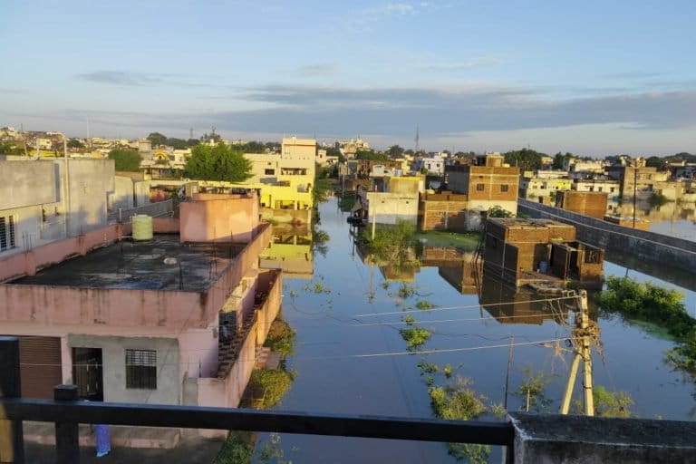
- The eastern Vidarbha region of Maharashtra flooded heavily in the last week of August.
- Extremely heavy rainfall in Madhya Pradesh led to swollen reservoirs, large discharges that inundated downstream areas in eastern Vidarbha. This again brought into focus the unique problem in the region, where the rivers originate and have their catchment areas and dams in Madhya Pradesh, while the floods happen in downstream Maharashtra.
- The dam and flood management in these rivers flowing through eastern Vidarbha becomes difficult because of this split between two riparian states.
- The floods also brought back the question of dam management. The Central Water Commission had issued notices to three dam operators for not following the reservoir operation schedule, but the latter claim it was as per schedule and their actions helped contain the extent and intensity of flood
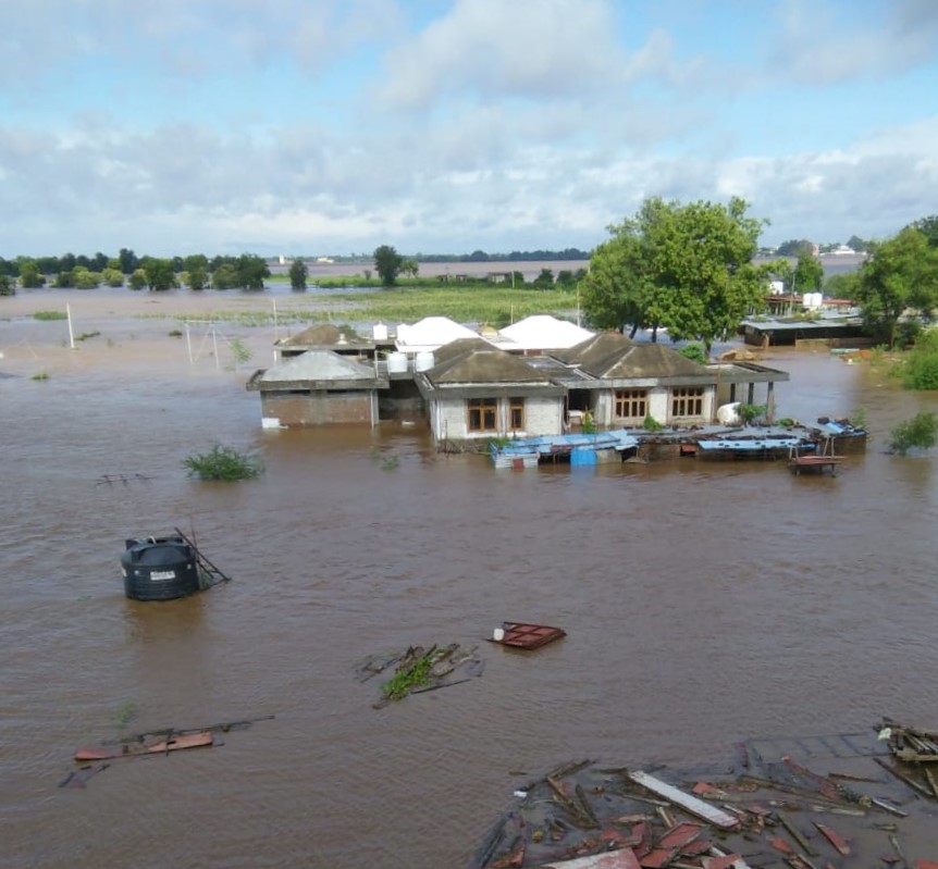
In the past few weeks, four districts of eastern Vidarbha region in Maharasthra flooded. This is a region with four major rivers, dozen-odd dams, almost 50 percent river basin area covered with lush green forests, amid the Satpura hill ranges of Madhya Pradesh – everything that otherwise is a prized asset with economic value. Extremely heavy rainfall in the region induced floods that left a trail of devastation along the riverine towns and villages.
Already in distress over the increasing cases of COVID-19 and loss of livelihood for many, thousands of people from four districts of eastern Vidarbha – Nagpur, Bhandara, Chandrapur and Gadchiroli – battled floods, following the substantial downpour on August 28 and 29.
While the areas flooded are in Maharashtra, the rivers originate and gather their water in Madhya Pradesh. All rivers in Nagpur, Bhandara and Gondia districts originate in the Satpura hill ranges in Madhya Pradesh. Their catchments are also in Madhya Pradesh. The quantum of rainfall in the catchment decides the fate of rivers in eastern Vidarbha.
Around 88,864 hectares (ha) of agriculture land in 34 talukas of Nagpur, Bhandara, Chandrapur and Gadchiroli was affected due to the floods. Even when floodwaters started receding slowly from August 30 and 31 onwards at many places, it had displaced people and damaged property along the villages and towns on the riverbanks. There was also large-scale crop damage and agricultural land inundation.
A team of experts from the central government, who toured the flood-affected areas in the four districts between September 11 and 13, were informed that close to 25,000 houses were damaged in these four districts. The team asked the local officials, “How did the flood happen?”
It prompted the old debate (like during the Kerala floods of 2018): did the multiple dams regulate the floods or add to the woes?
Was there a warning?
On August 28 and 29, the rivers Pench, Kanhan, Bagh and Wainganga and their numerous tributaries were in their full fury. So were the dams Sanjay Sagar and Gosekhurd (on river Wainganga), Chaurai (on Machchagora), Totladoh-Pench (on Pench), Rajeev Sagar (on Bawanthadi), the Upper Wardha dam (on Wardha) and three reservoirs on river Bagh.

The Central Water Commission (CWC) monitors dam storage and also does flood forecasting. It helps local/civic administration and disaster management agencies, 24 hours before (or sometimes 72 hours before) in deciding mitigating measures such as the evacuation of people and their movable property. Inflow Forecasting is sent to various reservoir/dam authorities.
Sharad Chandra, the CWC’s director (Flood Forecasting) told Mongabay-India, “The CWC does the level forecasting (for rivers) and it is the state government agencies that assess the threat perception and issue warning, which all areas would be inundated for a given rise in the river. They decide the threat perception and they disseminate that information.”
For Gosekhurd, the CWC had issued both, a three-day advisory and a deterministic forecast 24 hours before. The India Meteorological Department (IMD) had issued a forecast of ‘extremely heavy rainfall at isolated places’ for Eastern Madhya Pradesh.
“The Wainganga basin is divided into different parts and there was a special bulletin issued for Chhindwara from Delhi,” M.L. Sahu, the scientist who heads the IMD station at Nagpur said.
As alerted, there was widespread, heavy rainfall in the entire catchment area on August 28 through the day, and at many places on August 29 too. All rivers flowing down to Vidarbha from Madhya Pradesh were in spate, reminding elders from the region of how almost in a similar pattern, entire Central India had received massive rainfall in July 1994 and caused devastating floods in eastern Vidarbha.

Was the rule curve followed to prevent Vidarbha floods?
The CWC had in April 2020 come out with its annual document, SOP for Flood Forecasting 2020. The dam operators have also had their Reservoir Operation Schedules (ROSs) drawn up.
Dam operators maintain that any dam can be a most effective flood control measure, provided it is only for flood regulation. Almost all dams in central India are multi-purpose dams, with one or more functions – irrigation and power generation being most common.
This time around – as has happened in recent years in Kerala in 2018 and Karnataka-Maharashtra Almatti dam in 2019, there have been allegations – both from experts and common people – that all major dams in the Wainganga basin violated the set norms of reservoir storage and release of water. For instance, Gosekhurd not just inundated several villages with backwaters in upstream stretches but also caused massive floods in downstream areas.
The CWC has a Monitoring (Central) Organization (MCO) at Nagpur that keeps a tab on all dams in the Wainganga Basin. In a rare move for the CWC, this year the MCO issued notices to three dam operators – Upper Wardha, Sanjay Sarovar and Totladoh (Pench) reservoirs for violating the rule curve.
But each of the dam operators claimed the ground situation prompted them to do what was done and that all actions were according to ROS.
“Of the total 22,625 square km catchment of Wainganga at Kardha (a place just outskirts of Bhandara town), Sanjay Sarovar’s catchment is barely 2,000 sq.km. Likewise, Bagh reservoir’s and Bawanthadi reservoir’s catchments are 1,075 sq.km and 1365 sq.km, respectively. Rest 18,176 sq.km is free catchment,” said Praveen Mahajan, executive engineer, Sanjay Sarovar.
Ashish Mahajan, in-charge of the Chaurai dam, agreed that there is an ROS but till two years ago, the dams were never full on time because of uncertain rainfall. So, the priority is always to fill the dam, an indicator of why Chaurai was 90% full on August 28.
“Despite that we have to make real-time decisions depending on the flood situation, how much rainfall the dam receives etc. There are a lot of factors. We have a regular discussion with our seniors. Retaining water for storage is important, but so is saving the dam.”
He also reminds that it is not just Chaurai dam’s excessive discharge that had swollen the Totladoh reservoir. “River Kulbhera meets Pench before it reaches the Totladoh reservoir. There was heavy rainfall all over and Kulbhera too had its own discharge, not to mention the scores of big and small tributaries of both these rivers.”
Ashish Verma, a journalist from Balaghat district, pointed out how earlier, the rainfall was spread over weeks. “Nowadays, things have changed. So, the dam operators tend to fill it as and when there is rainfall. The problem comes when a huge quantity of water is released suddenly.”
That there was enormous rainfall all over, no one denies. Totladoh reservoir officials get data from IMD, according to which, 414 mm of rain precipitated at Chaurai while rain gauges in the rest of the catchment recorded an average of 277 mm rainfall.
“In fact, we took a risk. We retained water at 2.2 metres against the gate/ full reservoir level – we absorbed excess water – so that the downstream town of Mauda and other places along the river got more time for evacuation. Else, the flood would have been more devastating. Our discharge was maximum at 7,000 cumec (cubic metre per second). That is the reason there was no loss of life,” Pravin Zoad, Totladoh, Executive Engineer, Pench Irrigation Division, said.
His counterpart at Gosekhurd echoes the sentiment. “Our EDA (energy dissipation arrangement for dissipating energy downstream of the spillway smoothly into the river) s designed for once in 315 years flood – for 34,000 cumecs. The maximum inflow we had during this period was 32,400 cumec but our discharge was 30,2337 cumecs,” Ankur Desai, in-charge of the Gosekhurd project, said.
Desai informed that till Gosekhurd, Wainganga catchment area is 34,862 sq.km, of which 24,000 sq.km lies in Madhya Pradesh. Out of this, only 24 percent is controlled by dams; the remaining 76 percent is uncontrolled area and that flows to the river directly, from the scores of tributaries big and small, that all fall into Wainganga.
“Our dam storage is 421 million cubic metre (mcm), not including the dead storage. But the dam received intake 16 times more – 6,000 mcm. Even if my dam was empty, this was way too much of rainwater,” he said.
One of the dam operators that Mongabay-India spoke with actually claimed that they cannot rely entirely on IMD’s forecast as it goes wrong on some occasions and then “we cannot afford an empty dam” when the monsoon ends.
Himanshu Thakkar of the South Asia Network for Dams, Rivers and People (SANDRP) pointed out how the downstream flood character (of the river) totally changes after a dam is built – the river’s capacity downstream of the dam changes and water released in excess of 1,000 cumecs creates havoc downstream. “The dam operators are supposed to operate the dams in a manner that avoids such a situation. They are clearly guilty of violating the rule curve (an internationally-accepted way of reservoir management). Their defenses are meaningless,” Thakkar said.
Despite repeated attempts to reach out through call, SMS and WhatsApp text messages, officials at MCO did not respond to Mongabay-India.
Floods or Rabi crop?
The question remains as to how to balance the current need of saving downstream people from floods due to excess release of water suddenly and later day need by saving for the Rabi crop (sown in winter, harvested in spring).
Madhavrao Chitale, water expert and former secretary, Ministry of Water Resources, offered a contrary view. “Going beyond the technical reasons, dam operators generally are under local pressure from the farmers’ lobby, which is an important vote bank for politicians, irrespective of the party in power,” he said.
“Such floods cause crop losses in areas that are near to the river in the downstream areas. The damage due to flooding is approximately 10% of the annual income of that community. But if the dam operators take the risk, the water available for Rabi cropping helps with additional farm income as much as 30 to 60 % as the winter crop gets more value,” he added.
Editor’s note: The caption of the flood map was changed to correct a factual error.
Banner image: Floods in Bhandara. Photo courtesy Ashu Gondane.