
- Warming ocean leads to the rapid intensification of cyclones in the north Indian Ocean, a new study has said.
- Scientists studying cyclone Ockhi that hit the Indian coast in 2017 suggest the close monitoring of the Arabian Sea for future storms since climate projections indicate that the rapid warming in the basin will continue into the future.
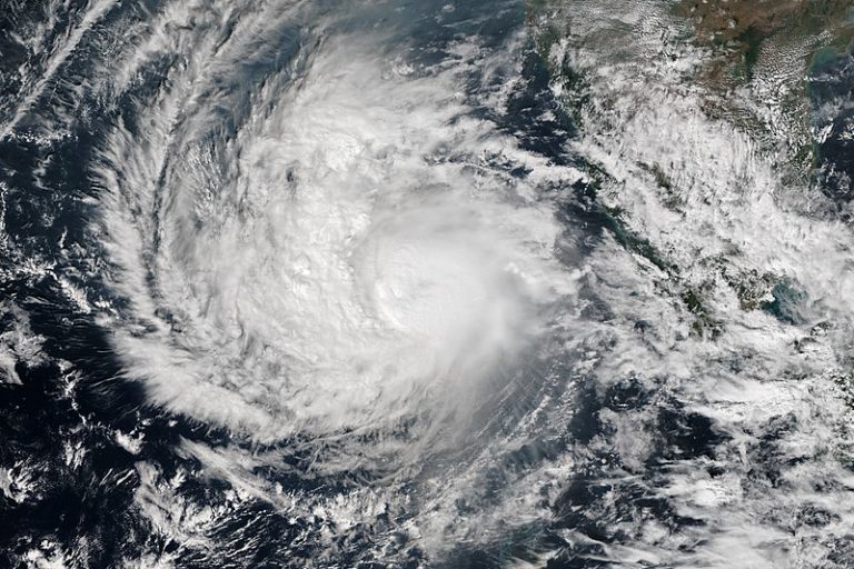
- Cyclone Ockhi was the first very severe cyclone to form over the Lakshadweep Sea since 1925, resulting in a death toll of 844 in India and Sri Lanka. It intensified rapidly from a depression to a cyclone in a span of nine hours and further to a very severe cyclone in 24 hours.
- The role of ocean temperature in the genesis and rapid intensification of the cyclone highlights the need for efficiently incorporating the coupled ocean-atmospheric conditions in cyclone forecast models.
Global warming causes rapid intensification of cyclones originating in the north Indian Ocean, a study has said. Scientists who studied cyclone Ockhi that hit India’s west coast in 2017 said that the Arabian Sea needs to be closely monitored for future storms since climate projections indicate that the rapid warming in the basin will continue into the future.
Researchers from the Indian Institute of Tropical Meteorology (IITM) at Pune examined the ocean-atmospheric factors responsible for the genesis, rapid intensification, and long track of cyclone Ockhi, the first very severe cyclone to form over the Lakshadweep Sea since 1925, resulting in a death toll of 844 in India and Sri Lanka. The distance traveled, duration, and accumulated cyclone energy were significantly larger for cyclone Ockhi, in comparison with earlier cyclones in the same region.
It intensified rapidly from a depression to a cyclone in a span of nine hours and further to a very severe cyclone in 24 hours. Generally, it takes 24 hours for a depression to turn into a cyclonic storm in the north Indian Ocean, based on records of cyclones from 1990-2016. In terms of energy, cyclone Ockhi was the fourth-strongest cyclone in the Arabian Sea during the post-monsoon season in the last 28 years.
“During the cyclone, the ocean water temperature was 29-30 degrees Celsius; this was 0.8 degrees Celsius above normal. The warm ocean provided energy to the atmosphere, causing the rapid intensification of the cyclone. The cyclone intensified near the Kerala coast, causing heavy losses,” study co-author Vineet Singh told Mongabay-India.
The present study shows that the Madden–Julian Oscillation (MJO) and warm oceanic conditions provided favourable dynamic and thermodynamic conditions for the genesis of cyclone Ockhi. Earlier studies have shown that MJO, an oceanic-atmospheric phenomena, plays a vital role in the genesis of cyclones in the north Indian Ocean by providing favourable background atmospheric conditions. The MJO involves variations in wind, sea surface temperature (SST), cloudiness, and rainfall.
The Madden‐Julian Oscillation is a “tropical phenomenon that includes heavy rainfall and stiff wind over an area of roughly 1,500 km in latitude and 4,500 km in longitude. It starts over the Indian Ocean and moves eastward to the Pacific Ocean in about a month. As it moves eastward, it influences weather and climate phenomena in many parts of the world. Understanding the fundamental physics of the MJO forms the base for forecasting it and its global influences.”
“Most of the prediction models failed to capture the genesis of cyclone Ockhi in advance and its rapid intensification. It shows that despite a lot of improvements in the prediction of cyclones there are uncertainties,” he added.
The India Meteorological Department (IMD) could not alert about the rapid intensification of cyclone Ockhi despite various models of forecasting cyclones, its severity, and intensification. This could be because the forecasting models do not include a combination of the study of the ocean, subsurface ocean, and atmospheric conditions, Singh said.
The study of the impact of ocean temperatures on cyclones is possible though it is in the initial phase. “There were not many studies of the north Indian Ocean till 1990 and ocean data was not available for scientists to study. Since 2001, ocean data is available,” said Singh.
Prolonged warm subsurface temperature over large parts of the south–southeast Arabian Sea helped cyclone Ockhi to maintain its strength for five consecutive days leading to large energy, which was 2.5 times more than normal, the IITM study stressed. This is in line with a recent study that shows that anthropogenic warming has increased the probability of extremely severe cyclones occurring in the Arabian Sea during the post-monsoon season.
Vineet Singh says the same pattern has been observed in cyclone Nisarga and cyclone Amphan that hit India recently in 2020. Nisarga made landfall near Alibaug in coastal Maharashtra’s Raigad district on June 3 as a severe cyclonic storm with a wind speed of 100-110 kmph gusting to 120 mph. On the opposite coast of India, barely a fortnight ago, cyclone Amphan barrelled into coastal West Bengal, Odisha (and neighbouring Bangladesh) fueled by unusually warm waters of the Bay of Bengal. It became one of the strongest cyclones in the recorded history of the north Indian Ocean.
“During Amphan, the surface temperature was 32 degrees Celsius, also the ocean subsurface was abnormally warm, and thus the entire column of the ocean was warm that fuelled Amphan to a category five cyclone. Generally, cyclones in the Bay of Bengal never go beyond category 2-3. This was unprecedented,” observed Singh.
“The study shows that if weather models are to predict the cyclone track and intensity accurately, they need to incorporate air-sea interaction phenomenon in the models in a better way,” J R Kulkarni, chairman, India Meteorological Society, Pune chapter, who was not associated with the IITM paper, told Mongabay-India.
Kumar Raghvendra, assistant commandant, National Disaster Relief Fund (NDRF), agreed that IMD could predict both cyclones Amphan and Nisarga in advance, which gave NDRF enough time to move people to a safer place. He added, “But cyclones keep changing tracks or their speed changes at last minutes. Nature cannot be predicted many times.”
About seven percent of the global tropical cyclones originates in the north Indian Ocean, including the Arabian Sea and the Bay of Bengal. And tropical cyclones are among the most destructive natural disasters on the earth. The cyclone frequency in this region varies between one and three in the pre-monsoon (March–May), and two and five in the post-monsoon (October–December). The socio-economic impact of tropical cyclones over India is considerable due to the densely populated coastal districts of the country with a population of 170 million, the study noted.
The frequency of cyclones is more in the Bay of Bengal than in the Arabian Sea: four tropical cyclones in the Bay of Bengal over one year, while the Arabian Sea experiences one. The total systems of cyclonic storms formed in the Bay of Bengal over an 80 year span (1933 to 2012) exceed those of the Arabian Sea because it is relatively colder than the Bay of Bengal, so fewer systems are formed. However, rapid warming is making the Arabian Sea fertile for cyclone formation. This could be one reason for an increase in the number of cyclones in the Arabian Sea, scientists have said.

Banner image: Cyclone Ockhi devastates Sri Lanka. Photo by Rehman Abubakr.