
- A study has pointed to the increasing anthropogenic stress factors in Amarkantak, the upper catchment area of the Narmada river in central India.
- The study raises concerns on land-use change, degradation of forests and overgrazing of grasslands, problems of siltation and pollutant influx in the river water leading to degradation of water quality and decreasing wetland spaces.
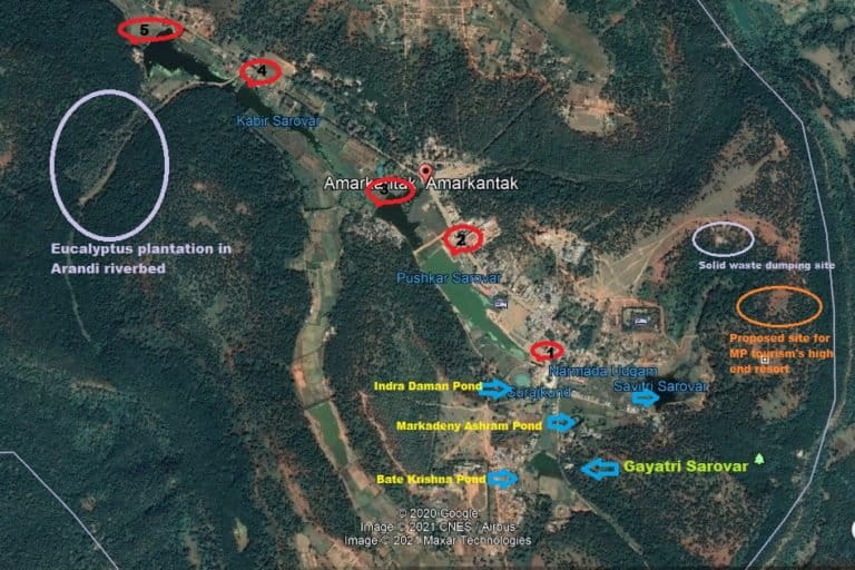
- As many as five check dams/barrages built on the first three km at the Narmada river’s origin at Amarkantak are restricting its ecological flow.
- Madhya Pradesh government and the Union Tourism Ministry have launched infrastructure development plans that focus more on amenities and cement work and less on ensuring an increase in the ecological flow of the river.
Amarkantak, the upper catchment area of the Narmada river in central India, has lost a significant percentage of forests and water bodies to agriculture and settlements in the last four decades, a recent study has said. This region (upper catchment area) is part of the Achanakmaar Amarkantak Biosphere Reserve (AABR).
According to the study, the biodiversity-rich region has lost 11.63 percent area of dense mixed forest (DMF), 2.11 percent of sal mixed forest (SMF) and 5.08 percent of water bodies (WB) from 1980 to 2018 while open land (OL) area has increased by 7.52 percent; agriculture (AG) has further spread by 7.10 percent and the areas under human habitation/commercial buildings (HB) have increased by 4.18 percent.
The major change in land use for DMF and SMF areas to OL, AG and HB areas accounts for almost 6.70 sq km of the total land use land cover (LULC) changes from 1980 to 2018.
Available online since December 29, 2020, the primary objective of the study was to understand the decadal land-use changes as well as identify the anthropogenic stress factors in the temple town of Amarkantak in Anuppur district of eastern Madhya Pradesh bordering Chhattisgarh.

The Vindhya and Satpura mountain ranges meet in eastern Madhya Pradesh, with the Maikal range being the pivot. A semi-circle shaped forested tableland catches the heavy rainfall. The inward and outward slopes make for a natural drainage that gives birth to three rivers – Narmada, Johila and Sone – embarking on further journeys in different directions.
With annual rainfall in the 1350 to 1600 mm range, the region is rich in biodiversity, endowed with dense, and moderate forests, mainly of sal, along with a variety of medicinal/herbal plants, justifying Amarkantak region’s UNESCO listing for Achanakmar Amarkantak Biosphere Reserve (AABR).
The stone-built pond at the centuries-old Narmada Udgam Sthal temple complex in Amarkantak, considered the birthplace of the Narmada, is fed by wetlands, ponds and two feeder streams, while downstream, several small rivers originating in the Maikal range – Kapila, Baitarini, Arandi, Arpa, Bakan, Tipan and Karmandal – provide a perennial source of water for Narmada.
Until about the 1970s, Amarkantak was no more than a sleepy hamlet. From the 1960s, there were bauxite mines that increased traffic to some extent but due to various reasons, the mines were closed around 2000. As per the 2011 census, the town with 1,952 households has a population of 8,496.
The town had just 35-40 makeshift shops near the temple entrance about 20 years ago. By 2010, there were 100-odd semi-pucca shops a little distance away, including those shifted away from the temple entrance. The swelling number of pilgrims increased the number of ashrams, most of them cement concrete buildings. Untreated sewage from many ashrams and residential properties found its way directly into Narmada. Forest and water have borne the brunt of the approximately 500,000 (five lakh) annual visitors to the town.
Depleting forests, poor health of Narmada’s feeder streams
“The results about the spatial extent of the different forest types and change detection from 1980 to 2018 indicates a steady decline in forest and water resource areas leading to shrinkage in the river basin,” the study’s corresponding author Tarun Kumar Thakur, head of the environment department at the nearby Indira Gandhi National Tribal University (IGNTU) said.
“Open Land, Agriculture and Habitation/Commercial Building have increased heavily, with unplanned industrialisation and urbanisation along the river valley. Lack of monitoring and scientific approaches can bring a death blow to these rivers. The upper zone of the Narmada is particularly important from an ecological viewpoint. The entire riparian ecosystem is dependent on good forest cover for sustainability. Vegetation mapping has revealed shrinking forest cover and degradation in forest health over the years,” he told Mongabay-India.
The study documented a total of 157 species potentially exploited and utilised by tribal communities of upper catchment areas of Narmada and highlighted unsustainable and overexploitation of resources leading to forest degradation as well.
The findings of the study are corroborated on the ground.
Dharmendra Dwivedi, one of the priests at the main Narmada temple, said, according to Puranic scriptures, Narmada has five feeder streams, underflows of which come together at the Kund (pond) at the temple. These feeder streams are, in turn, fed by five ponds/lakes: Indra Daman talaab, Suraj kund, Markandey talaab, Bate Krishna talaab (west of Savitri) and Pachari Pani, somewhere downstream of Sonmudha, on the eastern ridge of the Amarkantak tabletop, which once was a dense sal forest.
The Savitri feeder’s uppermost stretch is down to a trickle. A check dam at an altitude higher altitude the temple’s pond has created a lake that allows groundwater to percolate. Few metres downstream, the outflow from this waterbody is channelled between rows of ashrams and houses. Right outside the main temple, to its east, a sand-bag check dam creates another waterbody allowing for overflow from one side, to which meets the Gayatri stream coming from the south-west.
A few years ago, the administration merged the two streams and channelised them around the temple premises to drop into the Narmada soon after the bathing area. Unfortunately, people living on both sides dumped their untreated sewage into this channel, as a result of which, less than 100 metres from the temple gate, is the first sewage carrying nullah.

In 2019, the volunteers of Narmada Samagra, a Bhopal-headquartered NGO that works for rejuvenation of Narmada, with the help of Nilu Maharaj, another of the many designated priests at the main Narmada temple, carried out de-silting of Savitri’s channel before it merges with Gayatri. “We dug out several truckloads of silt, 15 feet deep, about 20 feet wide and at least 300 metres long,” said Neelesh Katare, Narmada Samagra’s local office-bearer. “The depleting forest is a cause of concern. Plus, there is eucalyptus plantation at several places here. This needs to be corrected.”
But ensuring ecological flow in the feeder and the Narmada mainstream is only half the problem. Solid waste and sewage are the other worries. A sewage treatment plant (STP) is in the offing but not without controversy about its location and function.
Chandra Mohan Thakur, District Collector Anuppur, said the STP will be away from the riverbank. “For the 12-14 km length of the river from the origin, the plan is to divert all sewage from falling into the river, treat it and send it away.” It is a three-year plan and will cover all big ashrams.
Five barriers in Narmada’s first three km
Fortunately, even with this kind of forest degradation, ample rainfall and geology have ensured good recharge. According to data available in the Assessment of Dynamic Ground Water Resources of Madhya Pradesh State as of March 2017, the entire Anuppur district is in the ‘safe’ category.
Yet, groundwater exploitation has increased with an increase in residential population and visitors, prompting the administration to dam the infant Narmada. The river in its first three kilometres is straddled by as many as five check dams built on it over the last three decades.
The first of the five check dams is in fact a small barrier to hold water between the bathing ghats built after bathing in the temple pond was banned to avoid damaging it. Next is a check dam that forms the Pushkar Sarovar reservoir built 20 years ago. In 2020, for the first time, de-silting was done by local volunteers when even the administration pitched in with some efforts. Due to a lack of funds, work fizzled out.
Narmada is now reduced to puddles of mud littered with remnants of solid waste. The dam was repaired later. Further downstream are two more check dams. The last one, beyond Kabir Sarovar, is empty after its retaining wall was washed away after Diwali last year. The administration has no plans to remove these dams to let Narmada flow freely again. These structures are needed to hold water, which in turn, recharges groundwater. “What we did last year was to stop permission for any new borewell,” District Collector Thakur said.
Legal recourse for pollution in Narmada
Four separate applications were filed between 2013 to 2017 before the National Green Tribunal (NGT) raising common concern on pollution in the river Narmada. Madhya Pradesh government informed the NGT on May 22, 2017, that under the Narmada Seva Mission launched by Prime Minister Narendra Modi on May 15, 2017, at Amarkantak, various steps are to be taken to keep Narmada pollution-free.
Madhya Pradesh Pollution Control Board (MPPCB) has been analysing water quality at 50 locations across Narmada and according to the latest report in August 2020, water quality has improved from class B to A at all locations, including at two points in Amarkantak.
However, the district administration has failed to strictly implement the NGT’s 2012-13 directives to not allow construction within 100 metres of the riverbed and there has been no check on haphazard construction close to the riverbed. An ashram at Chakrateerth, which has channelised the S-shaped Narmada’s flow at that location, and another ashram at Kapil Dhara standing within a few feet of the river flow, among others, are the prominent examples.
Dharam Veer Sharma, an advocate, filed a contempt of court petition against the June 2016 orders of the NGT’s central bench, following which a ‘show cause’ notice was issued to the district collector in December 2020. “The state government agencies and private parties, they are not even sparing this place of spiritual importance and heritage and destroying the environment,” Sharma said.
Swami Narendra Giri, who is the sanchalak (director) at Kapil Muni Ashram near Kapil Dhara, said, “Sadly, those in power, who can take action, are not doing anything.” Anjana Katare, elected member of the nagar parishad (city council), said: “Few big ashrams have political connections, and they do not need us for issues such as land allotment. They manage it from the top.”

Administration pushes for development
Despite so many concerns, the administration is bolstering a development model that entails more construction, although officials deny any such intentions.
Amarkantak was pushed as a mini-Smart City by Chief Minister Shivraj Singh Chouhan in 2017 when several projects were sanctioned, some underway, some completed. Thakur said one STP will be functional by May 2021.
On January 21, Chouhan and Union Tourism Minister Prahlad Patel under the Centre’s PRASHAD scheme (Pilgrimage Rejuvenation And Spiritual, Heritage Augmentation Drive) inaugurated a suite of projects at Amarkantak worth half a billion rupees (Rs. 50 crore). These include rejuvenation of the Indra Daman Pond and cantilever glass bridges at Sonmuda and Kapildhara. All this when Chouhan announced there would be no pucca construction in Amarkantak and no trees would be felled for any project, as reported by a local newspaper.
Collector Thakur said as part of the newly announced project, silt removal from Ramghat and Pushkar Dam would take place; work has already started for erosion prevention for the slope on the left bank.
Missing forest in and around Amarkantak town
There are 15 villages around Amarkantak town inhabited by the Baiga, Gond and Umraon communities and most of them depend on the forest for livelihood. Residents of the communities, H. Netam, M. Maraam and H. Tetam (full names withheld to protect privacy) said they sell firewood bundles to the hotel, restaurant owners and scores of ashrams.
Much of the forest surrounding Amarkantak town belongs to Amarkantak Nagar Parishad. Outside this is the Forest Department’s area with much of it under Reserve Forest and a small area demarcated as Protected Forest. Irrespective of the land ownership, the forest has been cleared for building more and more temples and ashrams and also for agriculture.
For example, a massive Jain temple currently under construction atop a hill to the north of the main temple. A chunk of green has been cleared away to make way for parking space, shops selling trinkets and snacks/water etc. A glaring example is how Kapila river is reduced to a trickle after people have started agriculture on its floodplains.

The steady increase in pilgrims has prompted the district administration to plan both affordable housing and a high-end resort-style accommodation in the forest right in the catchment of the feeder Savitri upstream of Narmda’s origin. Forest Department’s Omkar Goswami, Sub-divisional Officer (SDO), Anuppur, denied that the proposed resort was under their forest area. Collector Thakur said, “We will ensure that the design does not need tree felling nor have concrete structures, but mostly with wood, bamboo and locally available material.”
The forest department, in response to an NGT case regarding the removal of eucalyptus monocultures, has started mixed-species plantation for the last three years. However, nothing has been done to remove eucalyptus from the riverbed of Arandi, a small tributary of Narmada. The district administration has not planned any afforestation measures as yet. The aim is on low hanging fruits such as ghats development, pond beautification, high mast lights etc.
Priest Dwivedi sums up the situation saying, “Kuan jab banata hai toh neeche se judai hoti hai, ye log upar se jod rahe hai … (when a well is dug, the retaining wall is to be built upwards from the bottom. These people are doing the exact opposite).”
Banner image: First time in 20 years, work for de-silting the Pushkar Sarovar lake was started in 2020. The infant river is no more than a thin stream. The district administration carried out repair work for the barrage structure as a result of which the pond was empty for most of the time post-monsoon and showcased silt deposits mixed with municipal solid waste. Photo by Nivedita Khandekar.