
- Dams to generate hydropower, considered a clean energy source by many, were expected to usher development in Manipur but they have caused more damage than gains, alleges the residents of villages around operational, incomplete, and failed dams.
- Due to such projects, villages upstream of barrages have lost farmlands and forest resources, while those downstream have faced water crisis, economic stress and increased hardships.
- The state’s ecologically significant Loktak lake and the people living around it for centuries have undergone significant changes impacting local ecology and livelihood.
“Ngamu, pengba, ngaton or khabak, ngakra …” Tongbram Ahongjao names fish varieties that have gone missing from his environment over the past 40 years. A sexagenarian resident of Thanga, an island village inside Loktak, the largest freshwater lake of northeastern India located in Manipur state, he has seen the lake area change. “Moirang phou, kakching phou, chimlei, tao thabi…,” he continues, speaking of rice varieties that disappeared from the lowlands around the lake. To be fair, the lowlands disappeared in the first place.
At some mythological time, Poubi Lai, the giant, dragon-headed python, which lived under the waters of the Loktak lake, ate one man every night, until King Kabui Salang Maiba killed it with a trick, goes the legend. For centuries, Poubi Lai symbolised disaster at the community level for the Loktak people.
Then, four decades ago, in 1983, disaster came in the shape of a hydropower project, say the local people – the Ithai barrage on Manipur (or Imphal) river that uses Loktak as the reservoir. As of March 2022, the Loktak multipurpose project is Manipur’s only functional hydropower project, with an installed capacity of 105 megawatts (MW) of electricity, and is Manipur’s main source of power.
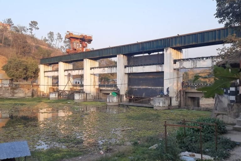
Declared a Ramsar site, or wetland of global importance in 1990, it was listed in the Montreux Record as early as 1993, signifying “Ramsar sites where changes in ecological character have occurred, are occurring or are likely to occur.”
Three decades since then, there is no dearth of stories that reflect the dirty side of clean energy.
“Tao thabi (a rice variety), in particular, was a great source of energy… it’d been a favourite with local sportspersons … And don’t forget the heikak (water chestnut), a cheap source of nutrition and also income, once found in abundance, growing increasingly rarer,” Ahongjao told Mongabay-India.
Among the fishes he named, ngamu is channa/snakehead, pengba is Osteobrama belangeri, ngaton or khabak is Labeo bata and ngakra is catfish, going by their other names.
At a young age, Ahongjao fished in the lake during monsoon and farmed on the lowlands during winter, just like most other people living in and around the Loktak wetlands. But the dam has impacted all local sources of nutrition and income – fish, rice and edible plants.
“Fish varieties dwindled because the Ithai barrage blocked the path of the migratory fishes that used to swim upstream from Bay of Bay Bengal through Chindwin river (in Myanmar) to spawn in Manipur river and Loktak lake,” environmentalist Salam Rajesh, a member of the technical committee of Manipur State Wetlands Authority, told Mongabay-India. “It took a big economic toll on the fishing community of the Loktak wetlands.”

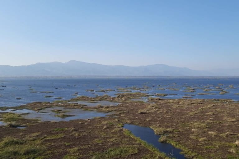
Sprawling over 230 square kilometres, Loktak is large; it has a direct catchment area of 1,064 sq. km. and serves as a source of livelihood for about 100,00 people living in and around the wetlands.
But size is not its claim to fame: it’s the phumdis, the floating islands of biomass that make Loktak a unique landscape. Described as ‘thick, floating mats of weeds covered with soil’ in the Ramsar listing, the phumdis usually have about 2 metres floating above water level and 3 metres below. They used to sink during winter to extract nutrients from the base of the lake. But that cycle has stopped. The water level never goes down.
The phumdis are also the only natural habitat of the endangered Sangai, the brow-antlered or dancing deer which dwell on a 22 sq. km. stretch of phumdis inside the 40 sq. km. Keibul Lamjao National Park, the world’s only floating protected area, is part of the Loktak landscape.
Before the barrage came up, the water level at the lake used to go down in winter, receding from hectares of lowlands, making them available for growing rice. But the barrage requires maintenance of a particular water level throughout the year. The lowlands never come out of water.
“Heikaks (water chestnuts) used to grow mostly in winter when the lake was less deep. Sunlight reached the bottom of the lake and helped the heikak germinate. Now, as the water level is always high, heikaks do not grow that much,” Budha Khwairakpam, a resident of Ithing village on the edge of the lake, explained to Mongabay-India.
Read more: Manipur’s native fishes in troubled waters
The National Hydroelectric Power Corporation (NHPC), which built and operates the project, claimed that apart from generating 105 MW of hydropower, the surrounding area “has also been benefited by development of infrastructure, education, medical facilities and employment avenues” and that the power station also provides lift irrigation for over 23,000 hectares of land in the valley.
Notwithstanding their claims, the demand for decommissioning the Ithai barrage has continued to grow. In 2017, the then Manipur governor Najma Heptullah had said at a programme that she was “working very hard for the removal of Ithai barrage” due to its adverse economic and ecological impact.
In fact, flood has become a regular phenomenon both in the villages upstream and downstream of the Ithai barrage.
Chairen, a village about 11 km downstream of the barrage, bore the burnt. “Chairen has been famous for its pottery. But sediments deposited by successive floods due to the barrage have covered the village’s original soil under layers. The new soil is unfit for their craft,” Jiten Yumnum, secretary of the Imphal-based non-profit Center for Research and Advocacy, Manipur (CRAM), told Mongabay-India.
A renewed thrust on hydropower projects
In March 2019, the government of India decided to declare large hydropower projects as renewable energy sources. Until then, only hydropower projects of lower than 25 MW of installed capacity were categorised as renewable energy, apart from solar, wind and biomass projects. The decision opened the door for a prospective boom in building large dams across the country – with the Himalayan region in northern India and the hilly terrain of the northeast being the prime target zones.
According to a Central Electricity Authority report, a total hydropower capacity of 148,701 MW has been identified across the country, of which 58,971 MW (39.65 percent) were in northeastern India. This excluded Sikkim (4,286 MW), which was clubbed under the eastern region. The report said, of the total identified capacity in the northeast, only 1,427 MW of installed capacity had been developed, leaving 93 percent yet to be exploited.
The lion’s share of identified capacity in the northeast goes to Arunachal Pradesh, 50,328mw or 85 percent of the northeast’s total potential, followed by Meghalaya (2,394 MW), Mizoram (2,196 MW) and Manipur (1,784 MW). Manipur had 94.04 percent of its identified capacity yet to be tapped, the report says.
In 2020, following the union government’s drive, and perhaps backed by the confidence of five years of relative peace in this insurgency-affected state, the Manipur state government decided to push for hydropower projects. It said it estimated the state’s hydropower potential at more than 2,000 MW and identified 29 new projects with a total proposed installed capacity of 300 MW.
These include projects with a capacity as low as 0.44 MW and 0.78 MW to 49.5 MW. Five of them are above 25 MW of proposed/tentative installed capacity, meaning large dams – Barak 4 HE Project (49.5 MW), Irang 3 HE Project (46.50 MW), Ijai HE Project (28.70 MW), Imphal HE Project (28.3 MW) and Barak 3 HE Project (26 MW). The state planned to get the detailed project reports for these 29 projects to be formulated by 2022.
Work on another big-ticket project, the Loktak Downstream Hydroelectric Project (66 MW) on 211.5 acres of land on Leimatak river in Tamenglong district, is also finally set to start after a long delay of over two decades. In 2020, when the Manipur government signed the power purchase agreement, its project cost was pegged at Rs. 1,311.05 crores (Rs. 13.11 billion). Land acquisition is expected to start anytime soon.
“Ithai barrage, instead of irrigating 50,000 hectares as promised, actually flooded a similar size of land. The Loktak downstream project is going to see a similar outcome,” said Yumnam of CRAM.
But for environmentalists in Manipur, the state’s experience with Loktak is not the only reason to trigger anxiety when they hear of more dams, especially large dams. There are other dams, failed or incomplete dams, which never took off but added huge costs to the state exchequer and misery to the people living around the project area.
Manipur’s power minister Thongam Biswajit Singh, who also holds the portfolio for environment, forest and climate change, did not respond to Mongabay-India’s queries.
Read more: Hydropower project nudges a tribal community out of their land in Himachal Pradesh
Old wounds spark fear
Khuopam dam was constructed in 1978 as the first dam in northeast India, on Machengdui river in Tamenglong district. Its irrigation canals collapsed over a decade ago, causing loss of farmland and income from fishing. Another dam, the Khuga dam in Churachandpur district took decades to complete and has been defunct since its inauguration in 2010, though it impacted fishing, farming and keeps flooding downstream villages regularly. It has neither produced any electricity nor generated revenue. The more recent Dolaithabi dam has also run into rough weather soon after its hurried inauguration.

Ram Wangkheirakpam, convenor of the Imphal-based non-profit, Indigenous Perspectives, said that whether big dams can be called sources of clean energy has been questioned worldwide because of their wide-ranging adverse impacts and Manipur stands as an example.
“Take the case of the Mapithel dam on Thoubal river. It took the state government decades but they have not completed it yet. This supposedly multipurpose dam has not supplied water for drinking and irrigation and has not generated any electricity,” he told Mongabay-India.
Alleging that the government had not properly rehabilitated any village, he said, “Affected people have been left high and dry by just giving them some cash compensation.”
The multipurpose project on river Thoubul was sanctioned in 1980 for an estimated cost of Rs 47.25 crore (Rs. 472.5 million). People in some of the villages were displaced in the 1990s, while some others had to leave in 2015 after the villages submerged following the shutting down of the watergates. In 2012, the project cost of this centre-state joint venture was re-estimated at Rs. 1,387 crore (Rs. 13.87 billion) at the price of 2011 and in 2016 re-estimated as Rs. 1,694 crore (Rs. 16.94 billion). The state authorities had informed the National Green Tribunal (NGT) in February 2016 that “Rs. 1,202.391 (Rs. 12.02 billion) crores approximately has already been spent till February 2014.” It was formally inaugurated in 2020.
This inordinate delay, to some extent, has been due to protests.
Among the upstream villages, Loupong, Maphou Kuki and Chadong are totally submerged, while Lamlai Khunou, Ramrei, Riha, Thoyee and Sarkarphung have been badly affected. Tumukhong, Moirangpurel, Laikhong and Nungbrang are among the downstream villages affected by the Mapithel dam.
“We have got only 60 percent of the promised compensation. They haven’t given us the church, land and other livelihood options they promised,” said P. Mahangmi, headman of Lamlai Khunou, dominated by the Tangkhul Naga, a Scheduled Tribe.
At the neighbouring Ramrei village, Themson Jajo produced a February 2022 reply from the Manipur water resources department to questions filed under the Right to Information (RT) Act, 2005. The total fund utilised stood at Rs 997.77 crore (Rs. 9.97 billion), of which Rs. 550 crore (Rs. 5.5 billion) was paid to two construction companies. Rs. 22.71 crore (Rs. 227.1 million) was paid as compensation for land and Rs. 39.54 crore (Rs. 395.4 million) was deposited to district authorities for disbursements as an economic package.
“Farmlands on the upstream are submerged and downstream they are dry, running short of water for farming, fishing and animals. Then, there are floods,” Chadong resident Dominic Kashung told Mongabay-India.
Chadong disintegrated into four separate habitations – Chadong Maphou, Chadong Original, Chadong West and Chadong New Site – separated either by the lake or the hills. At Ramrei, which originally stood on the bank of the Thoubul river, four-fifths of land and forest resources are now on the other side of the river.
“Getting access to resources means taking the boat, crossing the river…,” Jajo said, as weary creases formed on his forehead.
Read more: Purulia pumped storage project shows why pumped hydropower may not be clean
Banner image: A fisherman rows his boat in the lake through phumdis. Photo by Snigdhendu Bhattacharya/Mongabay.