- Tropical cyclones are large weather systems of rain and wind, formed around a zone of low atmospheric pressure with a steady exchange of hot and cold air.
- There are seven regions of tropical cyclone occurrence globally, with the alerts, naming, and warnings regulated and handled by the designated Regional Specialized Meteorological Centres (RSMC).
- With rising global sea surface temperatures, cyclone occurrence and trends have been changing, with the frequency of occurrence increasing in the Arabian Sea by 52% over two decades.
Tropical cyclones are fairly common weather systems, clocking a global average of around 80 storms annually. However, with rising global temperatures and subsequent increase in sea surface temperatures, the trends are changing, and dramatically.
What is a tropical cyclone?
A tropical cyclone is a large weather system that forms around a zone of very low atmospheric pressure, driven by very strong winds. Forming primarily over warm water bodies during the warm pre- and post- monsoon months, cyclones are often accompanied by heavy rain and strong winds, both of which cause varying degrees of destruction based on the intensity of the cyclone.
How is a cyclone formed?
Each individual cyclonic event is the cumulative result of several processes including evaporation, cloud formation, winds, the Coriolis effect, and the formation of a low-pressure area.
Cyclogenesis is the process of cyclone formation and typically starts with heat from the surface of warm oceans escaping into the atmosphere through evaporation. Oceans are the largest heat sinks on the planet, trapping over 90% of the excess heat on Earth, and are the regions where maximum warming due to climate change has occurred.
The lighter warm air rises up in the atmosphere, leaving a low-pressure depression below where the colder, denser air descends and rushes in from the surroundings. This moist warm air upon cooling at the colder, higher altitudes forms rain clouds that bring precipitation. Repeated rapidly and persistently, this process results in winds circulating above the warm water body, with the heat rising from the ocean continuously fuelling the system. Winds in the Northern Hemisphere are deflected towards the right due to the Coriolis force, resulting in counter-clockwise spiralling winds that gain more energy, resulting in a tropical cyclone.
The cyclone forms around the low-pressure area, called a depression, along a zone of cold and warm air exchange called the ‘eye wall’. The eye is the central and calmest part of the cyclone. From this eye wall, long, arching cloud and rain systems called rainbands spiral outwards, which bring alternating periods of intense rain and calm spells during a cyclone.

Where do tropical cyclones occur? How are they categorised?
Tropical cyclones occur worldwide between 5°-30° latitudes around the equator. The Coriolis force plays a major role in the formation and thus, cyclones don’t occur between 0°-5° latitudes since the Coriolis force is negligible at the equator. The world is divided into seven geographical tropical cyclone basins of which the Western Pacific sees the most cyclonic activity and the North Indian Ocean is the least active basin.
Tropical storms are called hurricanes in the Atlantic and north-eastern Pacific Ocean, typhoons in north-western Pacific Ocean, and tropical cyclones or severe cyclonic storms in the south Pacific and Indian Oceans.
The North Indian Ocean (abbreviated as NIO) basin includes the Bay of Bengal and the Arabian Sea, and cyclones forming in this region directly affect India, Pakistan, Sri Lanka, Bangladesh, Thailand and Myanmar, and in rare cases, countries of the Arabian Peninsula.
Read more: Floods, cyclones caused maximum deaths by extreme weather events in past 50 years
Every region has a Regional Specialized Meteorological Centre (RSMC) responsible for categorisation and nomenclature of each storm. Most regions have different criterion for classifying tropical cyclones based on wind speeds and intensity. The Indian Meteorological Department (IMD) is the primary agency responsible for weather forecasting in India, and monitors all tropical cyclones forming within this basin between latitudes 100°E and 45°E, and has assigned a seven-level categorisation for cyclones based on wind speed, which ranges from a low-pressure depression (D) to a super cyclonic storm (SuCS).
Similarly, in the north Atlantic and north-eastern Pacific Oceans, hurricanes are classified based on the Saffir-Simpson Hurricane Wind Scale which rates the storm from Category 1 to Category 5 in increasing order of intensity and wind speeds.
How are cyclones named?
Prior to the late 1900’s, cyclones worldwide were named arbitrarily after places affected, ships sunk or caught in the storm, and even Catholic saints. Since most ships had female names, cyclones were predominantly assigned female names. Male names were introduced in the late 1970s, and soon afterwards, a system of naming cyclones was introduced.
The Indian Meteorological Department is the regional body responsible for assigning names to each cyclone developing in the North Indian Ocean, and serves as an advisory body to 13 countries affected by the NIO basin. After the exhaustion of the original list compiled in 2004 when cyclones were first named in this region, all 13 member countries have now contributed a list of 13 names each, making up a list of 169 names that will be assigned to any future cyclones forming in the basin. Names are proposed following certain criteria, key ones being that the names should be politically and culturally neutral, consist of a maximum of eight letters for ease of reference, and not be offensive, rude or hurtful.

When is cyclone season in India?
Cyclones in the North Indian Ocean (which impact India, among other countries) have typically been observed to occur during the pre-monsoon period from April to June, and post-monsoon from October to December.
Nearly 7% of the world’s tropical cyclones form over the NIO, and the basin sees an average of five – six tropical cyclones annually, of which 4-5 occur over the Bay of Bengal and around 1-2 over the Arabian Sea.
Cyclones occurring in March, while uncommon, have been documented, the most recent of which was Cyclone Asani in March 2022. In the last 130 years of documented cyclones, only eight have been recorded forming over the NIO in March, and most dissipated over the ocean before making landfall.
Despite being the least active basin, the countries affected by cyclones forming over the NIO have very high population densities, resulting in recording some of the worst tropical cyclones in terms of damage to life and property.
Read more: From east to west, cyclones on Indian coasts are a reminder to put climate agenda ahead
Have cyclones become more frequent? How have cyclones been changing?
Over the last few decades, there has been an increase in the frequency and intensity of tropical cyclones forming over the North Indian Ocean. According to a recent study, the Arabian Sea, which historically saw the formation of an average of 1-2 cyclones per season, now reflects a 52% increase in cyclone frequency. In contrast, cyclone frequency over the Bay of Bengal has reduced by 8%, with a decrease in intensity as well.
The last few years have highlighted some concerning changes. The 2019 season was classified as one of the most active cyclone seasons that broke several records. As the third-costliest season in terms of damages, the North Indian Ocean basin saw its first Super Cyclonic Storm in over a decade, in addition to breaking the record of three Extremely Severe Cyclonic Storms occurring in one season. Of the eight cyclones that occurred, five alone formed over the Arabian Sea, surpassing both, the basin and Arabian Sea average.

Cyclones in 2020 and 2021 were more destructive, and underwent rapid intensification – a meteorological situation where the storm worsens considerably within a matter of only several hours. 2020 was the costliest season on record, with Super Cyclonic Storm Amphan being the strongest to have occurred in the Bay of Bengal since 1999, and the costliest in terms of damages since 2008.
The 2021 season saw a relatively uncommon phenomenon where remnants of Cyclonic Storm Gulab in the Bay of Bengal gave rise to Severe Cyclonic Storm Shaheen on the opposite coast in the Arabian Sea. This season also saw Extremely Severe Cyclonic Storm Tauktae undergo very rapid intensification before hitting the Gujarat coast, breaking the state’s record for strongest cyclone since 1998. Tauktae’s rapid intensification from a Depression to a Severe Cyclone was a record-breaking two days only, and according to some reports, this was the first Extremely Severe Cyclonic Storm to strike close to Mumbai in around 130 years.
While many climatologists are convinced of and link human activity-induced climate change as a contributing factor, the full extent to which anthropogenic factors affect cyclones is yet to be understood.
What does it mean for us, going ahead?
Global temperatures are predicted to rise by 1.5°C in the next few decades. Projections show that a sustained trend of warming could result in more frequent and devastating cyclones, with a larger proportion being very severe storms or worse. This is likely to be accompanied by increased rainfall, higher storm surges and intense floods, more damaging winds, and subsequent damage to life and property.
Of all the global sub-basins, the Arabian Sea is one of the fastest-warming sub-basins. A recent study found that the sea surface temperatures before cyclones have been 1.2-1.4°C in the Arabian Sea in recent years as opposed to sea surface temperatures four decades ago – an observation that coincides with the unpredictable and worsening cyclonic trends in the sub-basin.
During Super Cyclone Amphan in 2020, sea surface temperatures were among the highest recorded, measured at 32-33°C.
Read more: Floods less likely to be severe when cyclones hit dry land before monsoons, finds study
Globally, climatologists have observed an increasing trend in the intensity of cyclones over the last four decades, with the proportion of severe cyclones of the total occurring, increasing by around 5% every decade. According to some modelling studies, with an estimated 2°C increase in global temperatures by 2100, and a subsequent increase in sea surface temperatures, there could well be as much as a 5% increase in maximum cyclonic wind speeds, which would cause unimaginable devastation.
Historically, India’s east coast has been exposed to more cyclones and has a system of warnings and strategies in place; something that the less exposed western coast hasn’t mastered yet. To increase the country’s preparedness, the National Cyclone Risk Mitigation Project was approved by the government in 2015, and is being implemented in phases to fortify the early warning and mitigation systems in 13 cyclone prone states and UTs. Going ahead, with the changing trends, ramping up the cyclone mitigation and response strategies, as well as refining an early warning system along India’s western coast would be a crucial first step.
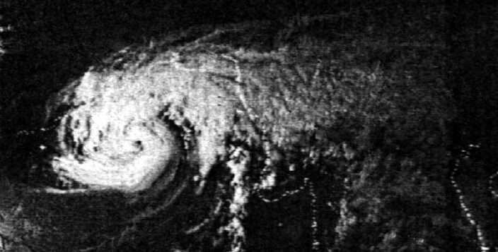
Banner image: A satellite image of Cyclone Bhola taken in 1970. The cyclone which struck West Bengal and Bangladesh that year, had a death toll of over 300,000. Photo from E.C. Barrett’s Climatology from Satellites, (London: Methuen, 1974), by Noaa/Wikimedia Commons.