
- Land use changes such as deforestation, extreme rainfall and exposure of slopes cut for the development of a key railway project likely contributed to a deadly landslide in the highly seismic western Manipur that killed over 60 people and injured many.
- It has prompted the railway authorities to look at monitoring mechanisms of hill slopes in sensitive areas and set up an early warning system.
- The state’s environment and climate change department has also suggested investigating links to climate change in the recent event.
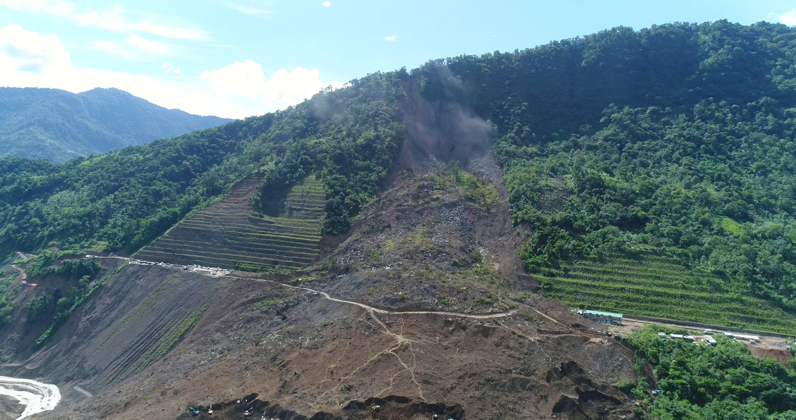
Sixty-one people died and 18 were injured after a massive landslide hit the construction site of Tupul Railway station on June 30. The Tupul substation is situated in Manipur’s Noney district. The railway project, which is part of the Act East policy through the Northeast Frontier Railway (NFR), aims to connect with the Association of Southeast Asian Nations (ASEAN) countries.
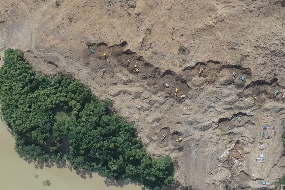
The first landslide occurred at 12.30 am on June 30, and the second at 6 am. At least 79 people were affected, of which, 18 were rescued. Of the 61 people missing, 56 were recovered during a 21-day search. Five people, including four civilians and one Territorial Army personnel were missing, and the search was called off on July 20, after Chief Minister N Biren Singh said it was decided to declare them dead. Thirty of the deceased were Territorial Army personnel, who were deployed to protect the construction site, while the rest were railway officials, labourers, and locals.
The disaster in the seismically-active western Manipur region is likely to have been caused by a combination of factors including excessive rainfall and long-term exposure of cut hill slopes for infrastructure expansion, debris blocking the flow of a river, and changing land use patterns such deforestation. It has prompted the railway authorities to look at monitoring mechanisms of cut hill slopes in sensitive areas and set up an early warning system. The state’s environment and climate change department has also suggested investigating links to climate change in the recent event.

Sanctioned in 2003-2004, the 111-kilometre-long Jiribam-Tupul-Imphal railway is a broad-gauge railway line that will pass through five Manipur districts: Jiribam, Tamenglong, Noney, Kangpokpi, and Imphal West. The project is estimated to cost Rs. 140 billion ($1,753 million), and 89% of it has been completed.
The railway line includes a total of 140 bridges, 11 stations, and 52 tunnels. The total length of the tunnel is 62.59 kilometres, and the longest tunnel is around 10.2 kilometres. The project is expected to be completed by December 2023.
The NFR recently said that the expansion of rail connectivity in the northeast has been a priority of the Centre.
What caused the landslide?
According to a preliminary study by the Geological Survey of India’s (GSI) Imphal office, the landslide was caused by an “extensive slope cut for the construction of the railway station, presence of break in slope in the upslope area, affluence convergence of water and unprotected slope cut for long duration (from 2014 onwards).” The report stated that the area where the landslide occurred is a ‘highly susceptible zone’, according to the National Landslide Susceptibility Mapping (NLSM) of 2019.
The other causes were listed as: debris dumps limiting the normal water flow of Ijei river; unconsolidated materials dumped and used for temporary construction sites; improper hillside drainage along the slope cut region. The site is 350 metres north of Ijei fault, making it a geologically weak zone.
However, the NFR, said that the GSI report’s statement of “extensive cutting of slope for construction of a railway station” was the cause of the landslide appears to be premature.
Sources from GSI, on condition of anonymity, said the final report is expected to be out in September. Sabyasachi De, Chief Public Relations Officer (CPRO) of NFR, said, “A report prepared by Manipur University specifically states that incessant rainfall this year, which is 400% more than the earlier recorded rainfall in the last decade, was the triggering factor behind the landslide.”
According to Manipur’s Directorate of Environment and Climate Change, Noney district received 329.9 mm of rainfall this June. It recorded the highest rainfall in the state for May since 2013, with 375.6 mm rain.
“The Tupul hill cutting, which was done in 2013, was carried out as per the specifications of the Research Designs and Standards Organisation, a research and development organisation under the Ministry of Railways,” “We had taken all necessary stabilising measures. And since 2013, till date, the measures have proven effective. But this incident happened because of the unprecedented rain,” De said.
Professor Arun Kumar, Earth Sciences department, Manipur University corroborated that the landslide undoubtedly was a result of unprecedented and heavy precipitation. “It is like one year’s worth of precipitation happened in one month. And it is a worldwide phenomenon, not just in Manipur. Even in places like Himachal Pradesh, you can see cloudbursts and rainfall happening. We cannot blame road construction companies here. These accidents happen in certain areas, not everywhere.”
Manipur-based environmentalist Salam Rajesh, who had visited one of the tunnels in 2017-2018, says he had noticed that a small landslide, too, could prove fatal. “The hillside was exposed and earth cutting was not done right. It’s basically soft red earth and most of the hillsides are sedimentary rocks combined with silt. So, when there is rainfall or an earthquake, landslides are common.”
Rajesh adds that the landslide area is near a village. “A major landslide would mean damage to property and lives. There have been protests by the locals as the hill cutting was likely to affect them.”
While mentioning a Manipur University report, Rajesh says that Manipur falls in the High Seismic Zone V, and hence, the microseismicity is active besides a large earthquake of 2016, which is near the recent landslide area. According to the report, it also seems to be one of the factors for the landslide, as few minor cracks are observed in the cut slopes of the railway yard.
The report further states that western Manipur has typical geological formations vulnerable to such landslides, and that the National Highways and railway network routes require regular monitoring of the slopes, in order to mitigate the future loss of properties and casualties. It says that along with heavy rainfall, change in the land use patterns on the top of the hill like deforestation, jhum cultivation, and banana cultivation, accelerated the soil erosion. These processes, might also be secondary factors for the landslide, the report suggested.
The landslide area was earlier investigated and identified as “high to very high hazard” in the unpublished doctoral thesis submitted and awarded by Manipur University’s Department of Earth Sciences in 2007.
The need for Environmental Impact Assessment
T. Brajakumar Singh, Joint Director, Directorate of Environment and Climate Change, Manipur, says that an immediate vulnerability assessment mapping is needed, along with a mitigation plan to evacuate all vulnerable communities. “We must also investigate the climate angle, as rainfall was quite high this time.”
While central projects do not require Environmental Impact Assessment (EIA) clearance, ecologically sensitive areas in the northeast such as Manipur or Sikkim should come under EIA, he adds. “EIA should be implemented ahead of any kind of project at least in sensitive areas, in the northeast. They should do a pre and post-environmental assessment.”
Rajesh shares a similar opinion, where he says that “EIA should be made mandatory in ecologically sensitive states. “ In a topography like Manipur which is prone to earthquakes and landslides, they should have done an intensive EIA first,” Rajesh said.
NFR’s De says that the Jiribam-Imphal railway project and all other projects undertaken in the northeast will be reviewed with a fresh perspective. “We are in talks with IIT Guwahati, Manipur University, and engineering institutes, to work out a mechanism for monitoring slopes in critical locations,” he adds. “We are looking at slope stabilisation techniques, and are trying to establish an early warning system to aid us in these situations. While we will not rush into anything; we are committed to our target of completing the project by December 2023, including the Tupul part of the project,” he added.
Arun Kumar says the incident has definitely been an eye-opener for the railways. “More observation and monitoring are required along all the sections in the hills in Manipur where the railway lines are exposed, so they can at least find out if there are any issues, and if the amount of precipitation is more. A warning system is required. There are also certain geotechnical solutions available to stabilise these slopes,” he said.
A major chunk of the tunnels have been completed and crores have been invested by the Indian government to construct these. If we can spend a certain percentage of money on remedial measures, it would be useful for such a prestigious and important project connecting Manipur to Southeast Asian countries, he said.
“Regular monitoring is important, particularly drone survey, as it is the most effective method to monitor these slopes. To monitor manually is not possible. Monitoring of precipitation is absolutely required. And if we can have some monitoring instrument, somewhere in the slope surface of 3-4 metres depth, it should also help in collecting information,” said Arun Kumar.
Banner image: Rescue work in progress around the Tupul landslide area. Photo from Preliminary Note on the Disastrous Tupul Railway Station Landslide, Noney district, Manipur report by Geological Survey of India