
- Lake sediments are useful paleoclimate proxies that provide information about the environmental changes and human-induced pressures on the ecosystem.
- Paleoclimate scientist Anoop Ambili talks about how information regarding the past climate changes in lake systems shape how we design policies that address human-induced changes.
- Ambili reports a large-scale destruction of important lake systems, disappearance of aquatic organisms and an excessive inflow of microplastics in water bodies. He stresses on the urgent need for policy changes to protect these systems.
Paleoclimate scientists travel to remote destinations in the planet to collect proxies. These proxies could be tree rings, ice sheets, corals, fossils or sediments from lakes. And they are used to reconstruct past climate data to understand the natural and human-induced changes on the landscape/ natural systems.
Lake sediments are indicators of sensitive environmental changes. Studying different lake systems in the Indian subcontinent through different years can give a paleoclimate scientist, a clear picture of anthropogenic-stressors and natural stressors over several thousand years.
In the fifth and the last episode of Imprints, Mongabay-India Contributing Editor and podcast host, Sahana Ghosh speaks with paleoclimate scientist Anoop Ambili, Assistant Professor, Earth and Environmental Sciences, Indian Institute of Science Education and Research – Mohali, to understand how analysing lake sediment cores from thousands of years ago, could help frame policies for today. Ambili explains why Himalayan lakes are the perfect study sites, what today’s lakes can tell about the natural and anthropogenic pressures of the past and why community-based conservation is important for India’s lake systems.
Listen here:
![]()
![]()
![]()

Full transcript
Sahana Ghosh (SG): You are listening to Everything Environment by Mongabay-India.
Lake-hopping is Anoop Ambili’s thing. Many of you may have been there – Lonar Lake in Maharashtra, Tso Moriri in Ladakh and Renuka in Himachal Pradesh. For Ambili, a paleoclimatologist, these lakes hide clues that help him reconstruct past climate changes going back 10,000 years.
Ambili’s work takes him to the Himalayas and central India and many other places. He is also studying microplastic pollutants in these freshwater lakes. For example, in Renuka lake, a popular tourist spot and also the largest lake in Himachal Pradesh, he is looking for pollutants such as microplastics. Information about the changes in the lakes, Ambili believes, will shape how we design policies that address human-caused changes to natural ecosystems.
Welcome to our show, Imprints. I am Sahana Ghosh, Contributing Editor at Mongabay-India.
In this episode, I’ll speak to Anoop Ambili from the Department of Earth and Environmental Sciences at IISER-Mohali, about what India’s lakes tell us about our past, present and future. If you listen to Ambili’s poignant observations of lakes and the challenges they face today, I’m sure you’ll look at these water bodies from a different perspective.
Before we begin, a bittersweet note – this will be the last episode of Imprints. In this series, we went on a journey with five paleo scientists from India. They took us lake diving, shell searching, ocean sailing and fossil digging. Their interviews revealed India’s fossil and natural history wealth, it put climate change and biodiversity loss in perspective and shone a light on scientists’ role in understanding our world. If you haven’t heard the previous four episodes, you can listen to them in any order.
Now, back to this episode.
SG: Hi Anoop! Welcome to Imprints. Can you start us of by sharing what led you to look at lake sediments as records of past climate as a career option?
Anoop Ambili (AA): Sahana, first of all, I thank you for this opportunity to share my research expertise and research highlights. My name is Anoop and I’m currently working as an assistant professor at the Department of Earth Science at IISER-Mohali. So, I am basically a paleoclimatologist. So, it all started during my Bachelor’s and Masters. I was quite fascinated about the changes in the deglaciation and the glaciation episodes in the past.
Glaciation and interglacial frame, it’s not mainly the deglaciation, so the interglaciation. So, the period of glacial episode essentially means where the earth is covered with ice; for example, off late, there was the Ice Age, during the Pleistocene time period. And, of course, the interglacial period essentially denotes the warming episode. So, if you look at the earth’s history, we know that the earth is 4.5 billion years old. So, if you look at the earth’s history, there have been times when there have been periods of or episodes of glaciated condition, where mostly the earth covered with glacier followed by periods of intense warming and glacial melt.
And most importantly, while learning about these deglaciation and glaciation episodes in the past, I was always wondering about what are the driving mechanisms and then how the ecosystem basically responds to the different climatic variabilities in the past. So later on, I joined as a PhD student under the supervision of Dr. Sushma Prasad, at Potsdam University. Dr. Sushma is actually an expert on the utilization of lake sediment as a climatic archive. So, actually, that’s where my journey started.

SG: In Earth’s history of 4.5 billion years, what part of that history do you work on? And where do you see the impacts of your research and data?
AA: See, the last century for example, has witnessed a series of floods and droughts. And of course, there is climate change, which has been associated with anthropogenically induced CO2 emission. And so, most importantly, there is the understanding of whether the present-day climate changes actually whether it is due to the natural variability or anthropogenic factor actually. Delineating them actually is very difficult because. So, you really want to go back in time and some of the articles which I read of late actually during my B.Sc. and Masters time actually this has basically triggered me to basically understand what happened in the present data timescales and to understand the driving mechanism or the forcing factor, I realised that it is not really so easy with the 100 years’ timescale. So, you basically have to go back in time.
Then I decided to apply or, or to do a science, which is of course has a societal implication, because of course, this paleoclimatic data can be used for not only to understand the present but also for future projection. And I decided to work on this aspect. Not only the longer timescale, climatic fluctuations, the shorter timescale, we basically hold these holocene periods like the past 11,000 years, if you look at the 4.5-million-year-old earth history, 11,000 years is a very short time.
But I decided that of course, there is also a lot of climate and even the cultural dynamics also come into play, so on how the climate shaped the human. So, all these things were very fascinating. So that’s why I decided to choose a time ago, especially the past 10,000 years, where you have both the role of natural as well as anthropogenic (climate change).
SG: Now that we have the context, I want to know why you select remotely located lakes for your studies?
AA: So, Sahana first of all, these lakes are actually a very important archive for understanding the past. So, archive essentially means something which basically record the past life and of course, there are various archives, which are being used to understand the climate change, for example, starting with tree rings. But the major difference between tree rings as an archive and a lake, actually is that tree things can give you data set for the past 1,000 years, but the lake sediments can give us information on millennial timescale as well as on millions of years scale.
So, then the question comes: how do we select these lakes? For example, now, we if you look at the present day, because lakes are omnipresent right. So, for example, the lakes are found almost across all geographical regions, but why do we select these particular lakes, especially in Himalayas or in other remote regions? The major thing actually is, in the present day if you look at any of the lake system, especially the urban lake, these are all anthropogenically modified. There is a lot of eutrophication, which is happening. And there is a lot of dredging and other anthropogenic pressure, which significantly modified this aquatic ecosystem. So, whatever we try to trace back in time, will mostly give you a picture of an anthropogenic variable, rather than natural variable. So that’s why we travel to these remote locations, where we mostly have this kind of pristine environment, which could tell us more about the natural rather than the anthropogenic (changes).
So, we do a lot of surveys. First of all, we look for lakes, which mostly have a closed basin. So, the closed system can store the sediments which are coming, which are being transported. And the second most important thing is we look for lakes which are also stratified, stratified in a sense, they have got a temperature difference in the top and the bottom layer. So, there is always a layering. The lake should be formed by tectonic processes. So, most of the Himalayan lakes are formed by tectonic processes. These tend to be a bit deep and old. So, we can get sediments which are being deposited for longer timescales. So, we look at various aspects. And most importantly, we conduct a series of surveys to understand or generate modern calibration data to see whether these lake systems are responding to climate or not. We also do it with some remote sensing images to see a lake level fluctuation. But more importantly, we do a series of field surveys across different lake systems and try to do a kind of a modern calibration and to understand how, in a modern system, they are responding to climate, and afterwards we retrieve sediments and then do a long-term analysis.
SG: Because you’ve been to so many of these lakes, there’s bound to be a couple of favourite spots right? So, what are your favourite spots and how do they differ from one another?
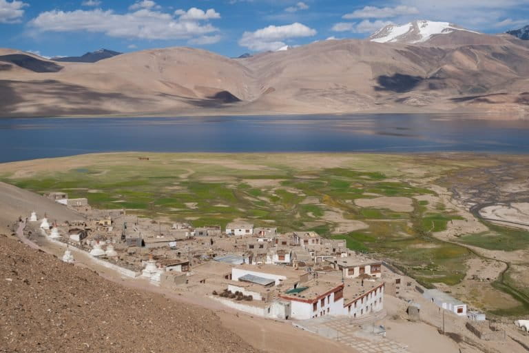
AA: The favourite spot I would say is of course, the northwest Himalayas. So, where I did my PhD (a part of my PhD), where I spent months looking at the lake systems. So of course, it is one of my favourite spots. And other than this, the Ladakh Himalayas – Tso Moriri lake, where we spent almost two months, doing extensive coring, deep coring – we raised almost like 10-metre cores from there. And off late, we have also visited Nagaland, a remote lake like Shilloi lake in Phek district, where we also did a lot of treks. So, all of these have their own unique characteristics. But of course, the northwest Himalayan lakes are very close to my heart. I spent a considerable amount of time looking at these.
I could take the example of the lakes in northwest Himalaya. So, these are basically a cold desert I would say because there is no vegetation cover. Now if you look at the other spectrum of the Nagaland lakes, these are all well covered with vegetation. To compare actually, it’s very difficult, but all have their own biodiversity and the ecosystems are quite unique.
SG: As you highlighted, these lakes are unique and they are witnessing changes, right? What are these changes? And did you notice any trends that have emerged in the recent years?
AA: Most importantly, changes in terms of see many of these lake systems actually have been found even in northwest Himalayas, some of them are formed in the past in a sense, all of a sudden there was a big landslide. See why there is a landslide happening in this region? It’s because there is no vegetation cover, there are steep slopes, there are plenty of materials which are available. So, this can have damming effects. For example, there is a big landslide and the river which is flowing is getting dammed and basically Lake has been built up. So, I have seen many of these changes because when there is a small amount of rainfall happening in this arid region, there can be big landslides. I have witnessed over the years because I have looked at like three to four years continuously starting, from 2008 to 2012, I have made continuous visits to these, these remote regions and have seen that every time of course, I have seen there are some geomorphological changes, there are new landslides. The lake sediment sometime which has been found along the valley, disappears. There are so many geomorphological changes I have witnessed every time.
There have also been landslides in the past. Because the Himalayas is actually an active tectonic region. So, there has been a landslide associated with earthquakes. So, earthquake-triggered landslides are always there. They have been there in the past, but it looks like the frequencies are actually different now. For example, if you look at the recurrence and the frequency, so, now, we are witnessing a bit more landslide when you start comparing with the past.
So, the scales are different, before there was more tectonically-induced or earthquake-triggered landslides. now it looks like there is more of a climatically induced landslide which is happening. Any landslide or flood which is happening now would actually have a devastating effect. This mountainous region in the Himalayas, especially the Indian Himalayas, are now one of the most populated regions in the world. So, any changes, any landslide, any flood event can be very devastating for the people living here.
SG: What causes a climate-induced landslide?
AA: What are landslides actually, these are movements under the influence of gravity. So, for example, if there is persistent rain for some time, then there can be water saturation and movement of material. For example, earth flow, mud flow these are all water-saturated mud or water-saturated materials. So, persistent rainfall can aid or trigger the movement of material along the soil. So that is what we basically call it as a climatically-induced landslide.
SG: So, could you take us through the importance of looking at multiple lake sites, as opposed to focussing at just one, to inform how the climate has behaved in the past?
AA: See, I have worked intensively in lakes across different geographical regions. So now, the question is why should we look at the lake system as different regions? For example, I have worked in lakes systems in western India, southern India, central India, and of course, the Himalayan region, which I have already mentioned. Now, the question comes: why a single study won’t work? Because in the Indian subcontinent, you know that of course, it is basically the monsoon, which mostly brings the precipitation to the country and almost 80% is being contributed by the southwest monsoon. But of course, there’s also additional contributions from the Northeast monsoon and also the northern Himalayas for example, is also influenced by the mid latitudes. So, you have multiple moisture regions, and if you look at the present-day precipitation scenario you are able to see there is so much spatial inhomogeneity in the precipitation right.
It is not possible to look at a single site and say that okay, “this is how the climate has behaved for the past 10,000 years for the Indian subcontinent”. So, we have to look at each different region and have to take a cumulative approach of really looking at how the climate was.
So, in that way we have actually looked at the lake system, for example, in Lonar lake in central India. So, it is a meteoritic lake and it is one of the what you could term it as a very high resolution multi proxy record. We have used multiple proxy and a very high-resolution study and it’s one of the well dated high resolution study, which has been carried out from this region, especially the central area.
We could see prolonged drought at different time periods for example, one of them actually between a time period of 4,600 years to 3,900 years roughly in the time window where this Indus Valley Civilisation collapse has happened and there was also a another prolonged drought, we have also observed based on the available proxy record.
Now, if you look in terms of looking at these mega droughts, which has been reported from Central India, and if you try to correlate with the Himalayan lakes and we weren’t able to find any of them. So, the Himalayan lakes have behaved quite differently from the lake systems, most importantly, the climate has been quite different when you start comparing central India. The same goes with the study from the Northeast Himalayas. When we start comparing the study from the Northeast Himalayas with central India, we were able to clearly see that there is quite a difference between the climate for the past 2,000 years. And now when it comes to the south Indian compared with the central India there, we could see a kind of an inverse relationship. So, our studies have basically pointed out that, of course, a reconstruction from a single site may not be useful, and you always have to use a kind of a multi proxy approach. And third most importantly, we were also able to find some of the forcing mechanisms, which may have resulted in the changes in these long-term climatic periods.
SG: Coming back to the core of our conversation and this show, what do these lakes reveal about the past 10,000 years?
AA: I could start with an example in central India where have we have generated a high resolution record from Lonar lake. From there we have seen if you look at the past 10,000 years, the time window from 6000 to 10,000 years, there was a very intense precipitation — we also call it as early Holocene intensification, which has been basically regulated by the incoming solar insulation. Then it was followed by a decreasing precipitation and all of a sudden between a time window for 4600 to 3900, we were able to see an aridity or a prolonged drought period, and then there was a bit of increase in climate starting from 3000 to 3,900 to 2,000 years. And again, there was an intensification from starting from 2,000 in the past 500 years.
We have seen that there has been a period of intense rainfall during the early Holocene and this we have also seen in the lakes in Himalaya. So, the various Himalayan Lake systems that we have also studied, we could also see a similar intensification in the early period. But the major difference was the timing; and because, there’s always a lag and second most important in the late Holocene, I was able to see in the past 5,000 years or so, what we saw in the lake system across India that there is a huge difference for example, the drought even which we have captured in the lake in Lonar, we weren’t able to find it in the lake system in Himalayas. So, there is a considerable difference between and of course, there are already reported various events. For example, there is a medieval warming period which has been well recorded in various European dates. So, they’re during this time, especially the 1,000 years, the past 1,000 years, there was this well known as a medieval warming period almost for a time window of 200 years. There was an intense precipitation. But in our lake system in central India, we weren’t able to find this similar event. So, even in the Indian subcontinent also the different climatic global climate events have also behaved differently.
SG: Can you throw more light on how having the knowledge of earth’s past climate history across a longer period gives us a precious opportunity to test climate models on longer timescales and reduce uncertainties in climate predictions? And how are you applying your research to the conservation of freshwater ecosystems?
AA: Yes, Sahana. So, the climate, what we have reconstructed from these lakes systems — I could take an example of the system which we have and studied from central India and Southern India. And as I already mentioned, we could see a kind of an inverse relationship, especially in the past 2000 or 3000 years. So, inverse relationship essentially means whenever there is a higher rainfall in central India, there is a relatively lower rainfall, which could be seen in the northeast monsoon for example, the north-northeast monsoon.
So, the Northeast monsoon essentially provides precipitation to the southern peninsula for example, the region like Tamil Nadu receives precipitation and they are dependent on it. So, now, I could to see that there is a shift or there is an inverse relationship in the past 3,000 years from our records, then, it could also be useful for a policy decision. We know by now, that of course, and also from the modern meteorological data supported by the modern meteorological data, if there is an increase in the southwest monsoon, then there can be a possibility of a decrease in the northeast monsoon. So, we can make our policy decisions accordingly.
Many of these higher resolution studies where we can make out the forcing factors can also be used in various modelling studies and could also be used for future projections. This has got a huge societal implication. Coming back to the freshwater lake system, we are actually actively working to understand the different anthropogenic stressors on these aquatic systems. For example, I have mentioned about why we are nowadays working in in a in a Himalayan Lake, because these are pristine, but now, the problem is that these lake systems are also undergoing anthropogenic stress. So, anthropogenic stressors in essence, there is so much eutrophication happening, and there is so much of organic contaminants which are nowadays coming into the system. And slowly these lake systems are getting worse. So, this freshwater ecosystem conservation, so, before we were mostly working to understand, to retrieve the climate information nowadays we realise that the conservation of these freshwater lakes is also equally important.
SG: So with this realisation, does it also mean that it is also getting difficult to find suitable study sites?
AA: See, the key challenges nowadays we face actually is finding a suitable lake for climate reconstruction because many of these lake systems are undergoing large scale anthropogenic modification for example, deforestation for example, there will be dredging activity happening. There is also large scale pollution influx into the system. So, before it was mostly natural modification of the ecosystem. Nowadays, it is mostly an anthropogenic, re-modified system.
The anthropogenic influence has taken a huge toll on the system, there is a regime shift, there is harmful algal blooms, there is so much which is happening or large-scale eutrophication, hypoxia. So, all these are basically happening in these systems, endangering many freshwater species in these remote lakes. So, that is of course, a huge challenge for us. The second (challenge) actually, we are trying to work in this report lake system. So, the logistic actually are always a big problem. Logistic in essential, for retrieving a lake. You always have to use a boat which is not mostly that there, carry large coring equipment to the field. And of course, it needs additional manpower and of course, huge amount of funding is essentially required. And the third important part of course is basically associated with the ambiguities of different proxies and how a proxy behaves in different settings. So, it is not really true that the proxy which I was able to use to retrieve the information in the northern Himalayas may not work in a lake sediment or a lake setting in the northeast Himalayas. So, you may have to use different proxy calibration methods to or have to make a calibration or do different modern calibration to make a more robust reconstruction. So, these are some of the key challenges working in the lake systems in the Indian subcontinent.
AA: All of the past I have extensively worked on the past 11,000 years, which essentially is the Holocene in time period. And whatever the climatic fluctuation which have happened, of course, in the late Holocene there is of course, some ambiguity in terms of there is already anthropogenic influence which have started, but of course, it’s only in the last 100 years it has intensified, but late Holocene there is some amount of anthropogenic activity started, but it’s mostly the natural factors, which mostly control the climate in the past 10,000 years except for the last 100 years.

SG: In terms of the human-driven pressures on these lakes in recent years, I think that plastics play a huge role. Have you looked at such issues in these lakes?
AA: So Sahana we are actively pursuing our paleoclimatic research using the lake sediments to reconstruct the climate. And secondly, we are also looking at, especially in the past 100 years, how these freshwater ecosystems are being shaped naturally and anthropogenically. And sadly, we were able to see that there is so much anthropogenic influence nowadays, in these freshwater ecosystems.
The conservation of these freshwater ecosystems is very important because of course, we use them for the drinking purpose and sustainability, this preservation of these freshwater ecosystems, their biodiversity is very important, especially for the Himalayan lakes. Sadly, what we saw from many of these lakes systems. So, for example, we have currently undertaken a project in two of the lake systems in Himachal Pradesh, for example, one called Renuka lake system in Himachal Pradesh, and then there is another one in Rewalsar. So, most importantly this is Renuka lake is a Ramsar site actually, a convention of wetlands. From 2005, it has been declared as a Ramsar site. And so, there should be protection for this wetland site, because it has got its own significance. But looking at the sediments in the freshwater lake system, we looked at the organic contaminants. In this organic contaminant essentially, I can take one good example of an organic contaminant which is the microplastic which is an emerging contaminant. So, microplastics are materials which basically range in size less than five milliliters. So, we looked at the concentration of microplastics.
This is the first study from the Indian subcontinent in a freshwater system in Himalaya and also additionally, we also look at their associated compounds with these plastics. For example, there are compounds called phthalates which are all present in this plastic material or microplastic and these all these organic compounds are carcinogens.
We have looked at these lakes systems and have found alarming levels of these materials in these lakes. So, this Renuka lake system is supposed to be a Ramsar site and has to be well preserved, but unfortunately there is a large-scale tourism activity which is happening. Similar goes with the Rewalsar lake which is also a lake which has got plenty of significance. But unfortunately, there is a large-scale degradation which is happening. We found a lot of carcinogens in terms of like the polyaromatic hydrocarbons, which are being contributed from the combustion activity. Then are sewage waste which are polluting these lakes with the large number of fish kills.
We are actively supported by national mission of Himalayan study to look at these kinds of organic pollutants, and we are trying to make awareness and of course, this is one way of putting across the message through people like you that these, the Himalayan Lake system is undergoing a rapid degradation and there is an important policy decision. So, we are submitting our reports to various, for example pollution board and to take to take measures and we are actively engaging with the society, and also trying to put forward our message that, “look, this system we need to preserve the freshwater ecosystems and we are we are dependent on them, we need to preserve it actually for our future.”
What I could able to see is that there has been natural induced changes in the past in these lakes. But there is a multifold change, for example, the 100 years or especially the past 30 years is the most critical I can see we have looked at the changes which has been for the past 100 years and we could able to see that from 1980 onwards, there has been multifold increase in anthropogenic induced pressure in the system. The new plastics coming in the polyaromatic hydrocarbon coming in, all these carcinogens which are coming into the system. There is a large-scale degradation in the system. So, they’re the disappearance of various organisms, which are already the disappearance of various aquatic species which are there, the tree surrounding the catchment which has been anthropogenically modified. So, there is a large-scale destruction which is happened. So, I think it’s time we should take note of this and should start working along to have some policy decision to make sure these systems are in place.
Read more: [Commentary] India establishes the largest network of Ramsar Sites in South Asia
SG: I can sense the urgency, the emergency in your voice, you’re sounding an alarm to conserve our freshwater lake ecosystems. Can you give me one example of an effective policy change that could perhaps address one such issue in our lake ecosystems?
AA: So, off late I made a visit to Renuka lake and have seen that they have put a ban on boating. So, this kind of policy decision I think would serve better, the same goes with Rewalsar before there was a large scale boating happened and of course, there has been fish feeding and of course, there has been sewage line and there’s an overflow of sewage line and when we have revealed our report that of course, there is a need and then the administration acted on it. They made sure that occur, there is no such Sewage contamination, which could able to come into this system and there is more awareness programme, which has been being carried out.
So, of course, Sahana, there needs to be more baseline studies like this, because in India, as I already mentioned, the Renuka lake, it was the first study in a freshwater system to look at these organic pollutants, but most importantly, the phthalate-associated microplastic. So, there is a more need of such study to look at. This actually is a baseline study and the processes need to be explained how they are coming to the anthropogenic wastes coming into the system, what essentially controls their distribution. There are so many things that need to be done.
So, to reiterate, a few studies are not enough to make any policy decision but of course, the initial studies help us to conserve these lake systems. And there should be more studies, more baseline data from different remote locations and even there is need to look at the Urban lake system. For example, in right near Chandigarh, we have this Sukhna lake and up for this large-scale tourism activity in which so, we need to look at all these systems and to then have to make appropriate measures because sometimes the pollution may be quite different, the compound which may be present might be quite different.
So, a single study may not be or a single compound may not be, so, we have us training for various compounds. So, a collective approach and we are right now trying to bring up a consortium of people to look at these various compounds in freshwater systems. And trying of course, you will need a lot of funding to carry out this analysis.
SG: What is this consortium going to do?
AA: So, the consortium is likely to be a set of scientists who are already working on these lake systems come for example, I have a few colleagues from Manipal University and then there are people from the IITM Pune and of course, various foreign collaborators through which we are also trying to see and see for example. My research group may not able to cover the in their system to do these kinds of screening or to get information on the different systems. So, there is a limitation in terms of funding and limitation in terms of manpower. Bringing people with similar backgrounds actually can help us to better make a data set, which can be available for the follow up. We plan to come together, and then write a project together, get funding, and also try to, to generate baseline data, which can be useful for future monitoring and can also be useful for good management of the aquatic ecosystem.
Read more: Story of a river bed, a geological marvel and community pride

SG: All these lakes that you study support communities. Considering the alarming situation that you highlighted, how important is local community participation in the conservation of these ecosystems?
AA: Sahana, I believe that the only way to preserve this ecosystem is community participation. And sadly, interacting with the communities in many of these ecosystems, I could not see much of community participation. But interestingly, in the northeast India, Shilloi lake in Nagaland, where we were able to see a kind of a community participation in the preservation of the lakes. And there the awareness, I feel that they are a bit more aware about preserving the lake. So, I think similar kind of community engagement and awareness theory, I think the people are not really aware of the health hazard, for example, the micro plastic, the associated compounds, I think, I don’t know many of them may not have even heard of the plasticizers we are using plastics and how harmful they are, they finally end up in our food chain.
There is an urgent need for awareness among the community and I think social media has a huge role to play. We are trying to coin a term known as social geosciences, where we are trying to actively engage, so the whatever the geosciences so, before what was the case what whatever results we have, it will remain within us or remain within the scientific community, it will not reach the local people. Now, through social geosciences, what we are trying to do is also trying to interact with the people down there. They are the ones who are able to actively make sure that the or, or actively make sure that the ecosystem needs to be protected, and there not be any degradation. And I think there is hope, if we are able to make sure there’s proper awareness among the communities.
SG: Thank you Anoop for giving us a sneak peek into the Earth’s archives hidden in lake sediments and reiterating the need for the conservation of freshwater ecosystems.
AA: Thank you, Sahana. So, I should thank you for this opportunity to convey the message to the to the relevant audience.
If you liked Imprints, please share this episode. Also, subscribe to our podcast, Everything Environment by Mongabay-India. We’ll bring more shows about India’s environment soon.
This episode was hosted and produced by me, Sahana Ghosh. Co-produced by Kartik Chandramouli. Edited by Tejas Dayanand Sagar. Cover art by Kartik Chandramouli. Copy edits by Sapna Verma and Priyanka Shankar.
Banner image: Pangong lake, Ladakh. Photo by Pawanmandawat/Wikimedia Commons.