- A cloudburst is an extreme weather event defined by the IMD as sudden rainfall of 100 mm or more within an hour over a small area.
- Monitoring or nowcasting cloudbursts require a dense radar network spread across areas where they occur, and very high resolution weather forecasting models to resolve their small scale.
- While newer Earth observation satellites promise better risk mapping and early warning, recognising unchecked development in high-risk zones is important.
Amidst climate change and extreme rainfall events, cloudbursts — sudden, intense rainstorms over small areas — are becoming a recurring hazard in India’s fragile mountain regions. Cloudburst events can trigger devastating flash floods and landslides. Extreme rain events can be even worse with other risks such Glacial Lake Outburst Floods (GLOFs) that occur when snow melts due to higher than usual temperatures and the heavy rain causes glacial lakes to breach, unleashing torrents downstream.
The recent disaster in Uttarakhand’s Dharali village reflects such growing threats, highlighting both natural triggers and human-made vulnerabilities. Poorly regulated development — roads, tunnels, dams, quarries and blasting on the unstable slopes — often amplifies the damage.
While NASA-ISRO’s NISAR mission and newer Earth observation satellites promise better risk mapping and early warning, real resilience will depend on enforcing environmental safeguards, strengthening local preparedness, and recognising that unchecked development in high-risk zones is no longer an option, experts note.
What is a cloudburst?
A cloudburst is a sudden release of downpour — an extreme weather event of rainfall over a small area (20-30 sq. km.); a rainfall of 100 mm or more in one hour recorded in a station, as the India Meteorological Department (IMD) defines it.
While cloudbursts are most common in mountainous regions like the Himalayas or the Western Ghats, they can occur anywhere. They only require building up massive amounts of moisture and which they release all at once. An Indian review of cloudbursts in the Himalayas shows that most of the cloudburst events occur at 1,000-2,500 m altitude in the valley-folds of the Himalayan southern rim.

“These cloudburst events are mostly associated with westward-moving cyclonic circulations in the middle troposphere (implying a cold-core in the lower troposphere) over the Tibet-Ladakh region during active monsoon conditions,” explained Vijaykumar P, assistant professor in the Department of Environmental Sciences, University of Kerala, Thiruvananthapuram. Troposphere is the lower atmosphere, where almost all weather phenomena occur — stretching from the Earth’s surface to 18-20 kilometres high at the equator, only six km high at the poles.
“The orographic forcing and strong convection leading to the formation of deep cumulonimbus clouds as high as 15 km are responsible for most of the cloudburst events,” Vijaykumar told Mongabay India. The orographic effect denotes air masses being forced to flow over mountains, cooling down, and the water vapour getting condensed. Convection is the vertical transport of heat and moisture in the atmosphere. Therefore, usually there’s comparatively more rain on the windward side of mountains, rainfall increasing with the elevation in the direction of storm tracks. Cumulonimbus, a type of heavy, dense cloud, is associated with rainfall and lightning.
Data, however, suggest that such isolated intense rain events alone may not cause cloudbursts. It is often intermittent hours of intense spell during continuous rain over a day or two that cause cloudburst.
What are different types of cloudbursts and their impacts?
“There are (mainly) two categories of cloudbursts,” said Vijaykumar. “An intense rainfall event that occurs in the Himalayan mountain ranges can produce flash floods, landslides, and loss of human life and properties. Such an event is category ‘a’ cloudburst (CBa) defined irrespective of the amount of rainfall. This is the one that happened in Uttarkashi in the first week of August 2025. Category ‘b’ cloudbursts (CBb) are events where the hourly accumulated rainfall is 100 mm or above over a smaller geographical area. Further, a third category of cloud bursts is called mini cloudbursts (MCB) which represents rainfall events where two-hourly accumulated rainfall is 50 mm or above. Such events can also produce flash floods and catastrophes like the other two categories of cloudbursts. MCB events have been found to occur over the Western Ghats region, mostly in July,” he explained.
These events can cause flash floods, landslides in hilly regions, and large-scale destruction downstream, often with little or no warning. In the Himalayas cloudbursts are associated with flash floods and sudden debris flow amidst heavy rain.

How good are cloudburst forecasts?
IMD monitors thunderstorms (rain clouds with lightning) that lead to cloudbursts through its surface observation network and Doppler Weather Radar (DWR) network. These networks share cloud images and wind speed figures every ten minutes and velocity of winds over the region they cover, contributing to nowcast (forecast with few hours lead time) thunderstorm activities. IMD also uses Numerical Weather Prediction (NWP) models to forecast thunderstorms and inform the public.
It is hard to forecast them, due to their very small scale in space and time, as scientists note. “It is hard to predict such events. They don’t reflect perfectly in numerical models,” Vijaykumar said. Thunderstorms can develop rapidly and the associated atmospheric processes in tropical regions such as India are very complex. Cloudbursts mostly occur outside observation stations over remote hills that are hard to reach. Therefore they often go unobserved and unreported.
Monitoring or nowcasting cloudbursts require a dense radar network spread across areas where they occur, and very high resolution weather forecasting models to resolve their small scale.
For instance, satellite data for the Dharali flood from the Indian Space Research Organisation (ISRO) showed indications of a flash flood, with widened stream channels, altered river morphology (shape and form of a river channel and its surrounding floodplain) and widespread damage to human lives infrastructure. The images show a fan-shaped deposit of sediment and debris at Dharali village, approximately a 20-hectare area at the confluence of the Kheer Gad and Bhagirathi rivers. The event has caused destruction and disappearance of several buildings in the flood-affected zone. Many buildings were submerged or got swept away in the intense flow of mud and debris in Dharali village.
How do improper development activities worsen cloudburst impacts?
While there is no clear information yet regarding the trigger for the flash flood in the Kheer Gad river, the event brings into sharp focus the need for better early warning and early action in the region known for cloudburst disasters, experts point out.
“The flash floods, landslides and the debris flow in Dharali exposed the fragility of the hilly terrain in the Himalayas as was seen in the flash floods and landslides in Kedarnath in June 2013 and the flash floods and landslides in Himachal Pradesh in 2023 and 2024,”said Vinod C Menon, founding member of the National Disaster Management Authority (NDMA) and an academic.
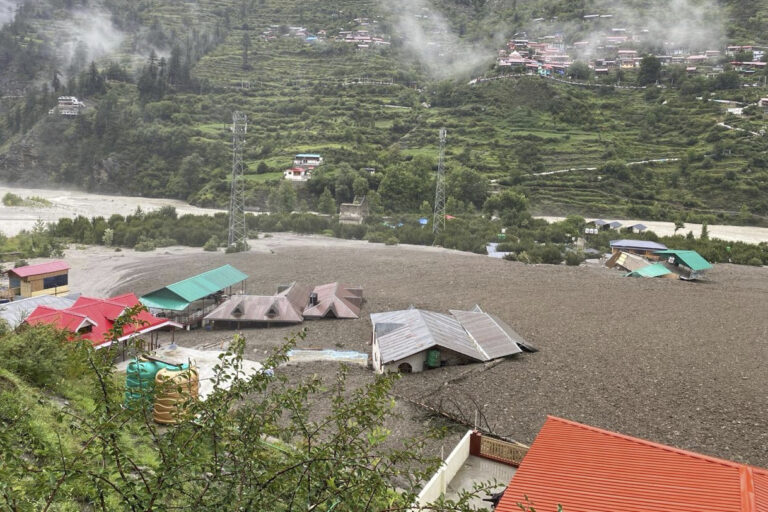
The cloudburst in Uttarakhand in June 2013 affected five districts: Rudraprayag, Chamoli, Uttarkashi, Pithoragarh and Tehri and more than 6,000 people reportedly lost their lives in this disaster. Twelve years later, the Dharali flashflood in which several people remain trapped under the landslide, raises questions about the impacts of improper development on slopes.
The construction of roads, dams, tunnels and highways cause instability, especially when explosives are used to blast rocks for development projects without considering the multi hazard risk and vulnerability. “Environmental Impact Assessments are not often carried out while initiating these projects,” Menon said. “Development projects must not rebuild risk in the fragile Himalayas putting the safety and security of people at risk of extreme weather events and disasters.”
How can emerging technologies reduce cloudburst risk?
Science and technology solutions which use Internet of Things (IoT) sensors to monitor water levels in rivers and dams, artificial intelligence and machine learning tools, drones, big data analytics and geo informatics solutions must be used to undertake multi-hazard risk assessment in high risk areas, Menon explained. “India has several scientific and technical institutions, academic and research institutions and professional bodies which have several disaster management practitioners with decades of experience in disaster risk reduction with appropriate skillsets and toolkits,” he added.
With the launch of the NASA-ISRO Synthetic Aperture Radar (NISAR) satellite, remote sensing can be applied for multi-hazard risk assessments of the high risk areas to assist risk-informed alert and early warning messages. “Officials of NDMA, SDMAs and DDMAs (state and district disaster management authorities) can alert communities and stakeholder groups in the last mile in high risk areas to save lives and protect livelihoods,” Menon added.
Science and technology solutions, citizen science and crowd sourced feedback of multi-disciplinary professionals and disaster management practitioners can also help in informed decision making, say experts.
Persistent scatterer interferometry with Synthetic Aperture Radar (PSinSAR) and Differential Interferometry with Synthetic Aperture Radar (DinSAR) can also help in monitoring deformations in built stock and critical infrastructure before, during and after disasters. PSinSAR is a powerful remote sensing technique to measure and monitor displacements of the Earth’s surface over time. DinSAR helps scientists detect ground movements with remarkable precision — down to just a few centimetres. The process works by comparing radar images of the same area taken at different times. Together, these technologies help in cloudburst risk reduction by mapping vulnerable areas and experts rely on these for early interventions.
Menon however noted that there must be “zero tolerance in any violations of regulatory techno legal mechanisms” and that institutions mandated for disaster resilience and climate resilience at the national, state and district levels must ensure strict enforcement and compliance of building codes at urban, peri-urban and rural areas, to contribute to cloudburst risk reduction.
Read more: Flash flood in the Himalayas reignites debate on development
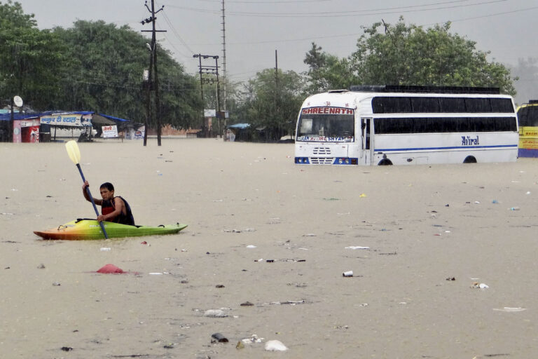
Banner image: A man rows past a bus partly submerged in flood water in Rishikesh in June 2013. Extreme rain during the monsoon led to flash floods, cloudbursts and landslides during this time in the Western Himalayas. (AP Photo)