- Constant manipulation of the slopes for constructing roads and buildings makes them increasingly vulnerable to any natural disaster risk.
- The Himalayas constantly remind us about the need for designing mountain-appropriate development pathways even while assimilating with the larger economic structure, writes Mongabay India Managing Editor, S. Gopikrishna Warrier, in this commentary.
- Himachal Pradesh is India’s hydel powerhouse, with an installed capacity above 10,000 MW across multiple projects, which is close to a quarter of the country’s installed capacity in hydro-electric power.
- The views in this commentary are that of the author.
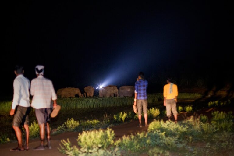
Last week I was in a group travelling in the Himalayas. Starting from the plains of Punjab, we travelled by road to an altitude of above 11,000 feet, to Chitkul, the last village in India before the border with Tibet. We camped along the Baspa river and spent an evening gazing at the snow-capped Kinner-Kailash range. We walked through a couple of Himalayan villages, getting a glimpse of the daily life of the residents.
This was not my first visit to the Himalayas. Again, I was awed by the majesty and grandeur. Once again, I became aware of the fragility of the environment, life and property in this mountain system.
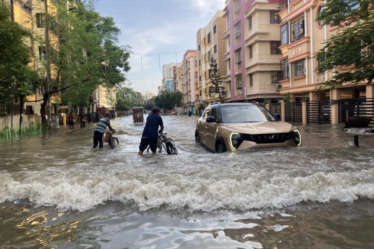
All through our way, roads were being repaired. These roads had taken a beating during the heavy rains in Himachal Pradesh during July and August. According to the India Meteorological Department data from Shimla, during the southwest monsoon period between June 1 and September 30, 2023, Himachal Pradesh received 20% surplus rains, with a 75% surplus in the month of July. The rain spells were in short bursts of high intensity.
The heavy rains, floods, landslides and loss of property and life have left a sad note in the memory of all the local people whom we talked with. The authorities were repairing roads with alacrity. There were two reasons. One, the state’s economy depends heavily on tourism and the broken roads had to be repaired so as not to obstruct the inflow of tourists. Two, the apples were ready for harvest and the trucks needed the roads to take them to markets in the plains.

As we returned to Chandigarh, we heard about the 6.2 on the Richter Scale earthquake in western Nepal. A day later it was the glacial lake outburst flood (GLOF) that swept away a hydro-electric dam on the Teesta river in Sikkim. Thus, in the recent months, all the natural disaster vulnerabilities were exposed for the Himalayas.
Driving along the Baspa river, these vulnerabilities were even more dramatically highlighted for us, as two hydro-electric projects use the water in the river near its confluence with Sutlej – one for 300 MW capacity plant and the other for a 1091 MW plant. Himachal Pradesh is India’s hydel powerhouse, with an installed capacity above 10,000 MW across multiple projects, which is close to a quarter of the country’s installed capacity in hydro-electric power.

This was not the first time that I was travelling in the Himalayas in the wake of a natural disaster. In October 1991, after the Uttarkashi earthquake, I was in Tehri region of Uttarakhand. The controversy over the Tehri dam that had been simmering, flared again after the earthquake and the subsequent aftershocks. Standing at the dam site, I remember looking up in awe at the near vertical walls of the ‘V’ shaped valley, where a few years later the 260-metre rock and earth-filled dam was constructed.
A ‘crumple zone’ with its own set of issues
The youngest mountain range in the world, the Himalayas pack so much of ice in its glaciers and snow-capped peaks, that it is considered as the Third Pole of the planet. The water from melting snow and natural springs below the snowline support the water needs of more than a billion people across South Asia and China.
The Himalayas emerged as the Indian Plate that had split from Gondwanaland moved across the Tethys Sea and crashed against the Eurasian Plate. Since the Indian Plate continues to move northwards, the Himalayas continue to grow by miniscule amount, despite the erosional pressures.
It is this pressure of tectonic plates pushing against each other that makes the Himalayas a seismically active mountain range. The Himalayas have had earthquakes measuring above 8 on the Richter Scale in the past. For instance, the Assam earthquake of 1897 measured 8.2 and again in 1950 it measured 8.7 on the Richter Scale. Scientists believe that a similarly intense earthquake could also happen in the future, with much energy being built up along the plate edges.

In this ‘crumple zone’ of the earth, seismic activity only adds to an otherwise unstable system. Folded and pushed into the air, the Himalayan mountain slopes are inherently less stable than the slopes of more matured mountain ranges.
A more recent risk in the recent decades with climate change is the threat of glacial lake outburst floods (GLOFs). When glaciers form and expand they carry at their lower end rocks and stones, which together become natural dams. With the mountains getting warmer with climate change, the lower end of the glaciers tends to melt. The natural rock and moraine dams hold back this water in the form of glacial lakes.

Natural erosion, seismic activity or a landslide into the lake can breach these natural dams and cause immensely intense flash floods downstream in the river. Since the glacial lakes form high up in the mountains above the snowline, the resultant flood can cause devastation downstream. The South Lhonak lake, from which the October 4 GLOF originated in Sikkim, is at an altitude of 18,000 feet.
The Intergovernmental Panel on Climate Change (IPCC), the global body that is the touchstone for assimilation of research findings on climate change, had noted with concern the melting of Himalayan glaciers in its assessment reports since 2007. Many of the large glaciers have recorded a retreat of above 25 metres per year.
Assimilate but stay distinct
On the roads of Himachal Pradesh last week, the dilemmas of the mountain communities hit home again. Local communities are aware of the fragility of the ecosystem in which they live and are aware of the threats and risks, but there is the aspiration to economically integrate with market economy of the plains and generate multiple sources of income for the state.
Connectivity is tenuous – roads get blocked or washed away at the drop of a rock. While flowing water is aplenty, non-sloping land for agriculture is scarce. Creating and maintaining terraces for sowing agricultural crop is back breaking. Thus, farming is done in river valleys or relative flat land adjoining villages, the slopes are used for grazing sheep and cattle. Horticulture, especially apple farming, provides a good income, but productivity has been declining, according to the state horticulture department, and post-harvest infrastructure is still inadequate.

A few decades ago, the armed forces used to provide the mainstay of employment for the men folk in the villages. The situation today is of course different, with cars, mobile phones, tourism and pilgrimage having taken over the economy.
It is these very cars that have blurred the boundary between the mountains and the plains and between the mountain-based economics and city-based market economics. Travel times have shrunk and it is very easy for tourists to travel from Delhi, or any other part of India, to reach the mountains. From the other end, more and more youngsters have been moving to other parts of the country in search of employment. Bengaluru is not far for an educated youngster from Himachal or Uttarakhand in search of a job in the information technology sector. Somewhere in this process, the truth that the reality of the mountains is distinct from that of the plains is forgotten.
These changes do come with a price. Constant manipulation of the slopes for constructing roads and buildings makes them increasingly vulnerable to any natural disaster risk. As videos from the recent Himachal floods showed, multi-storeyed buildings sank down the slopes with the rains.
The floods, earthquake and the GLOF that happened in the recent months are reminders of the ever-present natural threats in the Himalayas. With changing climate these events are likely to happen more frequently with higher intensity. The most effective adaptation would be to keep these fragilities in consideration while designing developmental activities in the mountains.

Years before Uttarakhand was carved out of Uttar Pradesh, Chipko movement leader Chandi Prasad Bhatt was asked by journalists about his views on the demand for a separate. “If you break a big stone into smaller ones, its inherent quality does not change,” was his cryptic reply. The Himalayas constantly remind us about the need for designing mountain-appropriate development pathways even while assimilating with the larger economic structure.
Banner photo: A snow clad mountain in Kasol, Himachal Pradesh. Photo by Chandramohan B V/Flickr.