
- A joint ISRO–NASA mission is set to kick off its next phase which includes data collection for scientific use, promising detailed insights into India’s forests, mountains, and disaster-prone regions.
- The earth observation satellite’s radar can penetrate clouds and vegetation, mapping subtle land shifts, landslides, coastal erosion and forest changes.
- Over its five-year mission life, scientists expect NISAR to share data of Earth’s changing landscapes in unprecedented detail.
Scientists and officials involved in disaster risk reduction are keenly awaiting the first images of the Indian forests and mountains captured by NISAR (NASA-ISRO Synthetic Aperture Radar), the joint mission of the Indian Space Research Organisation and NASA. The mission’s science phase, which is the operational phase, is slated to start in November, after the commissioning phase.
“Currently our scientists are finishing the calibration work,” NISAR project director and ISRO scientist Chaitra Rao told Mongabay-India in Bengaluru.
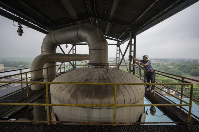
Calibration ensures that a measuring instrument or system records accurate values that match standards. In satellite missions, this involves checking and fine-tuning the instrument’s hardware and verifying its data against ground targets. For radar images, a usual calibration component on ground is a trihedral corner reflector that bounces off signals sent by the satellite in different directions.
Reflectors are placed in select locations, and they are often moved from place to place, Rao said. The Indian Himalayas and forest regions are of particular interest to scientists collating and analysing NISAR data, she added.
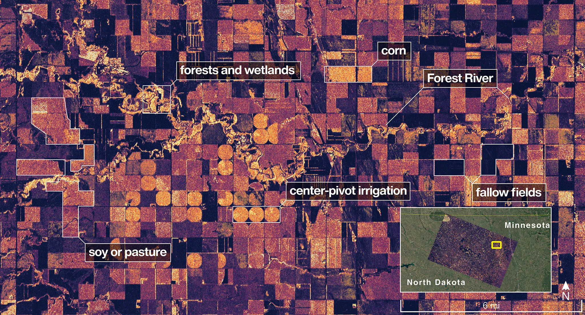
NASA published the first radar images of two places in the USA recorded by NISAR on September 25. “These initial images are just a preview of the hard-hitting science that NISAR will produce — data and insights that will enable scientists to study Earth’s changing land and ice surfaces in unprecedented detail while equipping decision-makers to respond to natural disasters and other challenges,” said Nicky Fox, an associate administrator at Science Mission Directorate, NASA.
On July 30, 2025, a giant GSLV-F16 launch vehicle carried NISAR from the Satish Dhawan Space Centre in Sriharikota. By mid-September NISAR entered its operational orbit, while NASA shared its first imagery recorded a month earlier.
For the first time GSLV, a launch vehicle meant for geosynchronous spacecraft, launched a spacecraft on a sun synchronous polar orbit. A sun-synchronous polar orbit goes around Earth pole to pole, crossing each spot at nearly the same local solar time to ensure similar lighting for images. On the contrary, a geostationary orbit keeps a satellite fixed above one point on the equator, allowing continuous monitoring of that region.
NISAR is one of the heaviest earth observation satellites weighing 2,382 kilograms. That explains the use of ISRO’s heavy-lifter GSLV instead of the Polar Satellite Launch Vehicle (PSLV), scientists said.
At the time of its launch the Union Minister of State for the Department of Space, Jitendra Singh, noted that the open-access policy for NISAR’s data will be of immense help to the scientists in India and other developing countries, disaster-response agencies, and those working in the field of climate change, worldwide.
Features of NISAR
A senior scientist at ISRO’s Vikram Sarabhai Space Centre (VSSC) Thiruvananthapuram noted that NISAR is a pioneering mission in many ways. Costing $ 1.5billion, it is the world’s most expensive earth observation satellite and is the first satellite to carry a dual-band synthetic aperture radar (SAR)—L-band from NASA and S-band from ISRO, the VSSC scientist said on condition of anonymity because they were not the official media spokesperson.
Radar images can reveal Earth’s features hidden from the naked eye or optical imagery. “Amidst human-induced habitat loss, biodiversity decline, and species extinctions, consistent measurement across landscapes remains challenging,” said Chethan Kumar Gandla, a wildlife expert who works with satellite data at Christ University, Bengaluru.
“Optical sensors capture reflected sunlight much like the human eye, making them ideal for showing visible surface features such as vegetation, water bodies, and urban areas. Radar sensors, in contrast, send out their own microwave pulses and record the return signal, allowing them to map the Earth’s surface even through clouds, vegetation, or darkness,” he explained.
“Radar sensors reveal structural and moisture details beneath as well as large-scale spatio-temporal information on habitat structures important for biodiversity conservation,” Gandla added. “Though both approaches are distinct, these remote sensing technologies have rapidly expanding applications in ecological research.”
Two SAR systems on board NISAR send pulses of energy from space and measure it as it bounces back from features on Earth. The L-band radar with its 25 cm wavelength signals can cut through woods and soil, helping scientists measure how wet, green, icy and stable down to fractions of a centimetre. The S-band radar with a shorter 10 cm wavelength is even more sensitive to smaller vegetation and structural changes.
NISAR circles Earth 14 times a day, 747 km above, scanning almost all its land and ice surfaces twice every 12 days. SAR pierces clouds, fog, and darkness, revealing landscapes, rivers, glaciers, and coastlines with high-resolution images, recording fine details invisible to the naked eye. Its all-weather, day-and-night capability makes it indispensable for everything from natural hazard monitoring to ecological surveys.
It uses a technology called interferometry to measure small changes in distance between objects on ground by recording radar images from nearly identical positions. Then its instruments can analyse how the radio waves combine and interfere with one another. By comparing these patterns, NISAR can detect subtle ground shifts with detailed images called interferograms.

Radar versus optical images
While NASA and ISRO share this data to the scientific community, there is considerable expectation among scientists across sectors that these images will contribute to better understanding of climate change impacts and improved disaster risk reduction. A government press release noted that over its five-year mission life, “NISAR will offer invaluable data for global climate science, seismic and volcanic monitoring, forest mapping, and resource management.”
“We used satellite SAR data during the landslide that occurred in Wayanad (in 2024). It was a cloudy day,” said Sekhar Lukose Kuriakose, Chief Resilience Officer, Kerala, and the member secretary of the Kerala State Disaster Management Authority. Data from NISAR could make significant contributions in understanding earthquakes and landslides, he noted.
“NISAR’s L-band and S-band SAR systems enable Interferometric SAR analysis — capturing millimetre-scale crustal deformation before, during, and after earthquakes. Its 12-day revisit cycle allows for consistent time-series deformation monitoring, essential for mapping strain accumulation along active faults,” Hamid Varikkodan, an expert in disaster risk reduction using satellite data at Jacobs, Bengaluru, told Mongabay-India.
“It can identify tectonically active zones and accumulation of strain for earthquake forecasting models. During and post-disaster, it can map displacement and aftershock deformation to guide emergency response and rebuilding. In the long-term, it can feed fault movement data into seismic hazard models, enhancing seismic zoning and building code updates,” he explained.
“Further, NISAR’s coherent backscatter capability (ability to detect and measure reflected radar signal) allows for ground deformation mapping on vegetated and rugged terrains, where optical sensors often fail. The L-band radar can penetrate through vegetation, making it ideal for detecting slow-moving landslides in forested or mountainous regions.” It can detect precursory slope movements and identify zones of progressive creep; rapidly map landslide extent and volume for relief prioritisation; and it can support slope stability monitoring in transport corridors, hydropower projects, and urban expansion zones, he added.
In the case of cyclones and coastal hazards, NISAR’s radar can map shoreline dynamics, coastal erosion, and storm surge inundation with high temporal resolution, Varikkodan added. “It can identify erosion-prone stretches and monitor the health of natural buffers such as mangroves and dunes. It can support flood extent mapping of storm surges in near-real time (in coordination with hydrodynamic models). It can also track coastal morphology change, infrastructure damage, and ecosystem recovery trajectories.”
The need for on-ground support
In a state like Kerala—vulnerable to coastal erosion, landslides and intense monsoons—NISAR’s all-weather, day-night radar capability offers a new dimension: persistent monitoring even under cloud cover, Kuriakose acknowledged. However, he emphasised that the country needs to “tremendously improve” its satellite data analysis expertise so that data is available readily. “Who will analyse these massive datasets? For every satellite launched ISRO should invest a matching amount to train and deploy people to process and share these datasets.”
Kuriakose also underscored the need to have enough ground support for rapid assessment and response. “In three hours after a disaster, after the initial shock and confusion, we need to assess the situation. My trained personnel can reach the spot in that timeframe and send a preliminary assessment. We can also fly a drone.”
Rao however noted that radar images potentially take 24–48 hours to get processed. “They’re not like optical images. It also depends where these images are downloaded. If it’s in a mainland station it can be quicker. If it’s in a station like Antarctica, it’ll take more time.”
NISAR ground stations are spread in different parts of the world — they include NASA stations in Alaska, Svalbard, and Punta Arenas; ISRO stations in Antarctica, Shadnagar, Bangalore, Lucknow, and Mauritius; and a station in Biak. Rao also stated that a dedicated team of ISRO scientists is involved in handling the data relevant to disaster management.
Read more: What are earth observation satellites? How do they support environmental research? [Explainer]
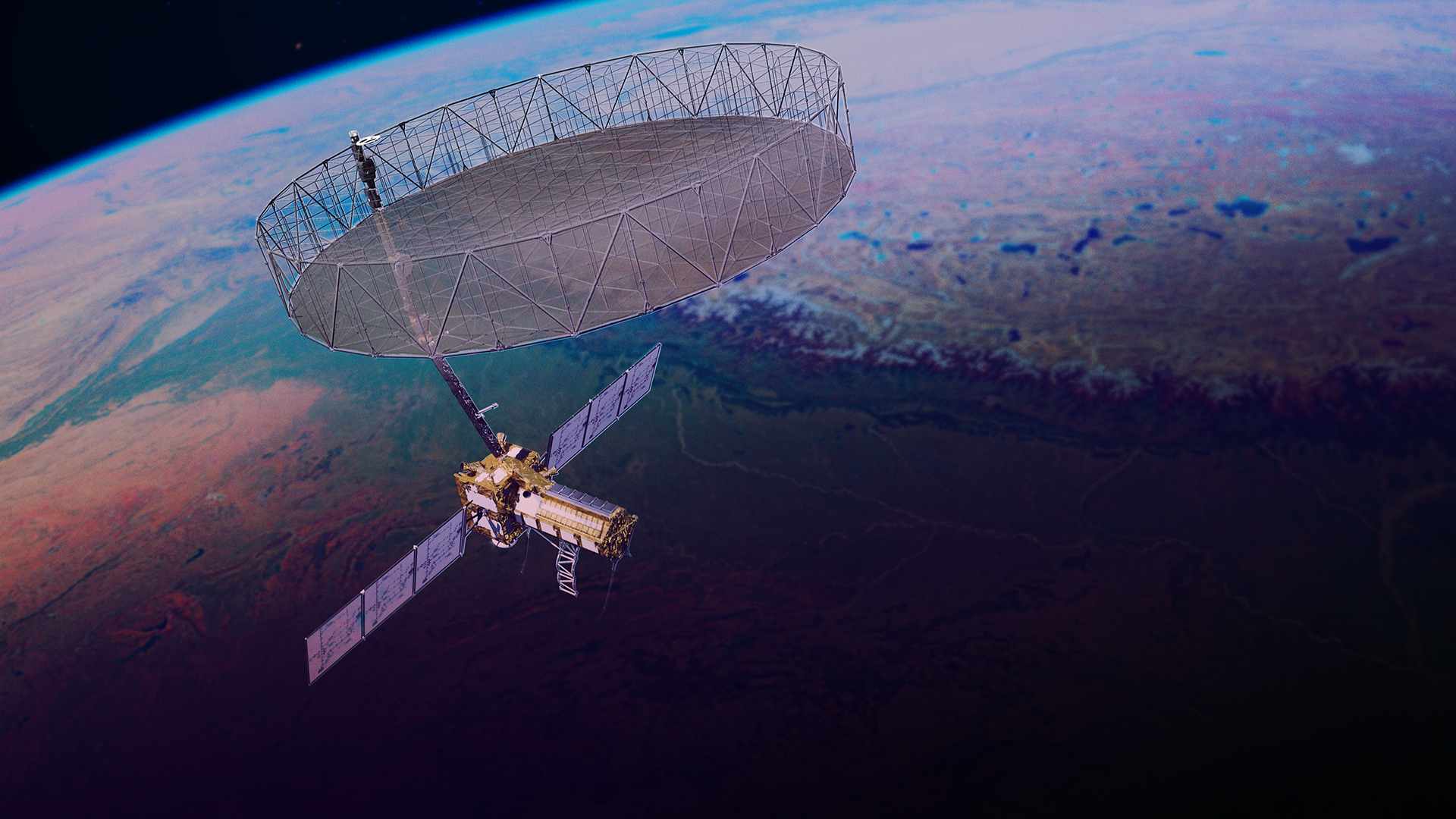
Banner image: NISAR with its fully integrated and deployed observatory system One of the prominent features is its radar antenna reflector with a diameter of 12 metres. A representative image by NASA/JPL-Caltech.


